The parts from Quang Tri to Quang Nam on alert as tropical depression expected to reach, heavy rain predicted
Viet Nam’s National Centre for Hydro-Meteorological Forecasting (NCHMF) provided an update on the movements of the tropical depression on Monday afternoon.
 |
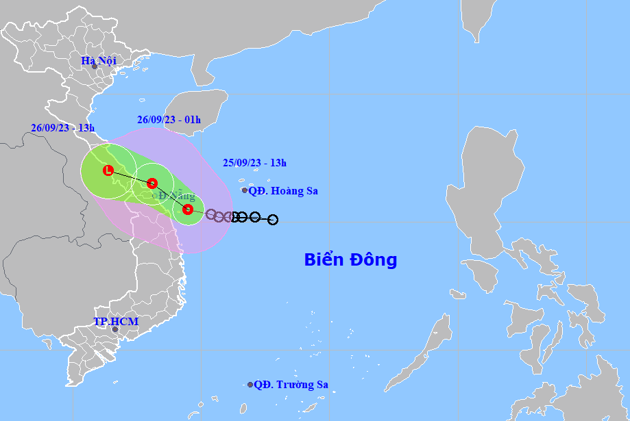
| The latest map and path of the tropical depression |
The depression’s center was located near latitude 15.5 North, longitude 109.5 East, about 150km east-southeast of Da Nang, about 150km east-northheast of Quang Ngai, NCHMF said in a bulletin at 1:00 p.m. on Monday, September 25. The system had maximum sustained winds at levels 6 to 8, and gusts of levels 8 to 9.
The depression is tracking towards the west-northwest at 15km per hour.
At 1:00 a.m. on Tuesday, September 26, it will be centered near latitude 16.5 North, longitude 108.1 East, sit over the open waters off the Quang Binh- Thua Thien Hue Coast. The system will have maximum sustained winds reaching levels 6 to 7, and the gusts as high as level 9.
The depression is expected to continue its west- northwest track at 15km per hour, and it is projected to reach the coast of the parts from Quang Tri to Quang Nam, including Da Nang, on Tuesday afternoon. The system will be then downgraded to a remnant area of low pressure and then dissipate as it moves father land.
Under the influence of the tropical depression, the open waters off the Quang Tri -Quang Nam Coast (including Con Co and Cham islands) could see strong winds at levels 6 to 7, gustiness of level 9 with rough seas.
Waves as high as 2-3m and 1.5-2.5m are expected to assail the open waters off the Quang Tri -Quang Nam Coast (including Con Co and Cham islands), and the Gulf of Tonkin, respectively.
Monday night into Tuesday morning, the coastal areas from Quang Binh to Quang Nam, including Da Nang, could see strong winds at level 6, and gustiness of level 8 while farther inland could see gusty winds at levels 6 to 7.
Under the influence of the tropical depression, moderate to heavy rain at most places with localized very heavy downpours occurred in North Central Coast and the Mid-Central region.
From 0:00am to 1:00pm on Monday, rainfall in excess of 150mm were recorded in some parts of these areas. In detail, as much as 283mm of rain dumped in Huong Phu (Thua Thien Hue), 81.7mm in Hai Ninh (Binh Thuan Province), 76.2mm in Cam An Bac (Khanh Hoa Province ), 197mm in Da Nang, 187mm in Trieu Ai (Quang Tri), 186mm in Huong Thuy (Ha Tinh), 171mm in Hoi An (Quang Nam).
Monday into Wednesday, heavy to extremely heavy rainfall is likely over the Mid-central region with the total rainfall amount expected to reach 100mm to 200mm in common across the region, and even over 200mm possible in some places of the parts from Quang Tri - Thua Thien Hue. Moderate to heavy rainfall and thunderstorm chance with isolated very heavy falls are in forecast for South Central Coast, Central Highlands and Southern region. Heavy rainfall of 100-150mm is predicted in common across these areas with more than 200mm of rain expected to dump at isolated places.
Monday into Thursday, September 28, as much as 200-400mm of rain could fall over the parts from Thanh Hoa to Quang Binh, and even more than 450mm at isolated locations.
Reporting by HOANG HIEP – Translating by H.L