Central Viet Nam, including Da Nang, braces for more heavy rains, big waves amid potential tropical storm warning
Meteorologists at the Mid-Central Region Centre for Hydro-meteorological Forecasting are tracking a new tropical depression intensified from the low pressure area (LPA) in the East Sea that was responsible for rains in Da Nang during Tuesday.
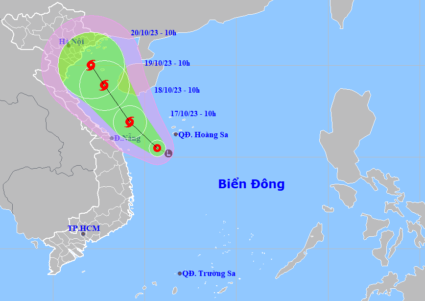 |
| The forecast track of the newly-formed tropical depression over the East Sea which is likely to strenghthen into a storm status. (Source: Viet Nam’s National Centre for Hydro-Meteorological Forecasting) |
Very heavy rain has lashed over Da Nang since early Tuesday morning, with 20mm-52mm of rain falling in an hour from 5:00am to 7:00am today in some places, which led to partial flooding on many streets.
An area of low pressure in the East Sea has become a tropical depression, according to the regional weather service. The system is expected to intensify and strengthen into a tropical storm status during the next 24 hours, according to regional forecasters.
As of 10:00 am on Tuesday, LPA had been upgraded to a tropical depression. Forecast models indicate that at 10:00am on Tuesday, October 17, the centre of the depression was spotted near latitude 15.5 North, longitude 110.7 East, about 150km southwest of Hoang Sa Islands, packaging sustained winds reaching level 6, and the gusts as high as level 8.
Over the next 24 hours, the depression will move toward the northwest in the East Sea at 10 km per hour, and it will continue to gain strength, and is likely to intensify into a storm.
At 10:00 a.m. on Wednesday, October 18, the soon-to-be-formed storm’s centre will be located near latitude 16.9 North, longitude 109.2 East, sit over the open waters off the Quang Tri - Da Nang coast, with maximum sustained winds reaching level 8, and the gusts as high as level 10.
Regional forecasters have issued a weather warning for strong winds and high waves to all vessels operating in the potentially dangerous area which is located near longitude 111.5 West, the open waters off the Quang Tri to Quang Ngai Coast, and southwest of North East Sea in the next 24 hours.
The potential storm will change its direction and track toward the north-northwest at about 10km per hour.
At 10:00 a.m. on Thursday, October 19, the potential storm will be centred near latitude 18.9 North, longitude 107.8 East, lie to the south of the Gulf of Tonkin with the maximum sustained winds reaching level at 8, and gusts at level 10.
Under these conditions, the offshore area stretching from Quang Tri to Quang Ngai, including Da Nang, the southwest of Northern East Sea (including waters of Hoang Sa islands) will see gradually increasing wind at levels 6 to 7, then increase to level 8, and the gusts reaching level 10, and experience rough seas with waves as high as 2-4m.
Heading into Thursday morning, moderate to heavy rain with isolated extremely heavy rainfall and thunderstorm chance is likely over the parts from Quang Binh to Quang Nam, including Da Nang, but there will be a gradual decrease in rainfall over Quang Ngai.
Heavy to very heavy rainfall forecast alert for Tuesday into Thursday morning, has been issued for the parts from Quang Tri to Quang Nam, including Da Nang. Heavy rainfall of 100mm - 250mm is predicted in common across these areas with more than 350mm of rain expected to dump in some places.
During the forecast period, Ha Tinh, Quang Binh, and Quang Ngai are being warned to brace for moderate to heavy rain with localised very heavy downpours, with the total rainfall amount expected to reach 50mm to 150mm in common, and even over 200mm possible at isolated locations.
The regional weather service is warning residents of heavy to very heavy rains in Da Nang and Quang Nam from Tuesday into Wednesday night. These areas are being warned to brace for heavy rain, with rainfalls of 100-250mm, whilst some places will receive even more than 300mm of rain.
Rain activity is expected to declince gradually over Da Nang, Quang Nam and Quang Ngai from Wednesday afternoon.
Regional weather forecasters have also issued warnings of flash floods and landslides for mountainous areas, and localized flooding alerts are in place in low-lying and urban areas. The warning covers the parts from Quang Binh to Quang Ngai, including Da Nang.
The regional weather service is urging authorities in affected areas to take appropriate precautionary measures to cope with floods, flash floods, landslides brought by heavy downpours, in order to minimise losses owing to heavy rain.
Reporting by HOANG HIEP – Translating by H.L