Koinu weakens, cold front to usher in cooler temperatures this week
As Tropical Storm Koinu continues its journey across the northern East Sea, it is expected to weaken and dissipate over northeast Hainan Island of China Tuesday morning, Viet Nam’s National Centre for Hydro-Meteorological Forecasting (NCHMF) has said.
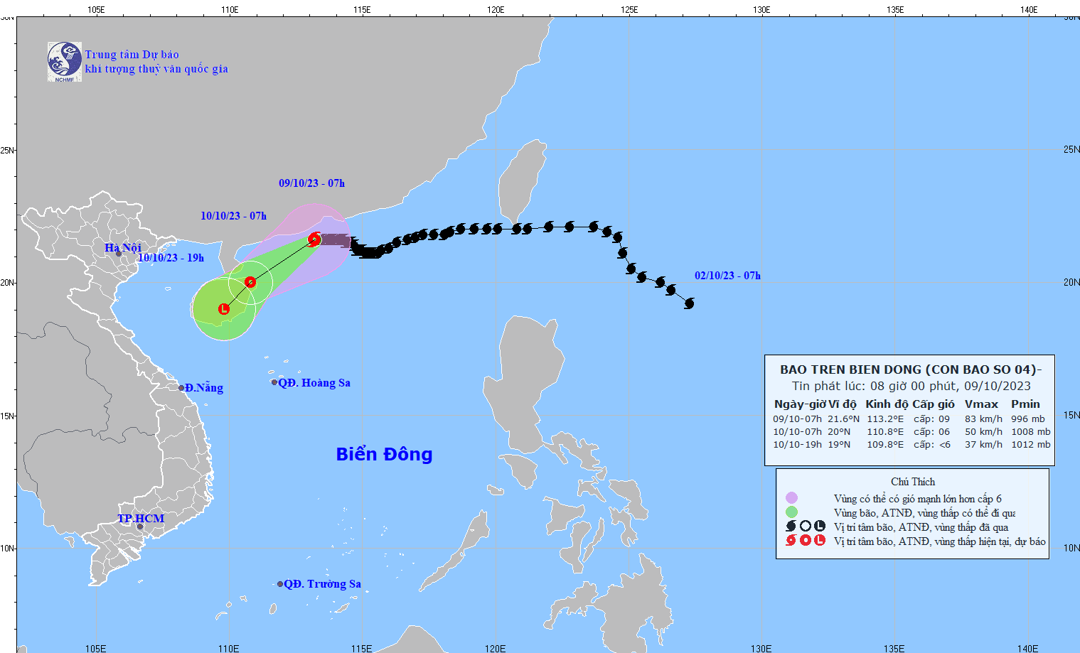 |
| The projected Koinu path and map (Source: NCHMF) |
Koinu made its way to the East Sea on October 5, and it became the fourth named tropical storm of 2023 in the East Sea.
NCHMF reported at 7:00 a.m. local time on Monday, October 9, typhoon Koinu’s eye was spotted near latitude 21.6 North, longitude 113.2 East, and sat over the open waters off the coast of the southern Guangdong Province of China. It was packing maximum winds of level 9 (88 kilometers per hour) near the center and gusts of level 12 as it moved slowly westward at about 5 kilometers per hour.
While Koinu, which killed one person in Taiwan last week, had weakened into a severe tropical storm.
As severe tropical storm Koinu has weakened into a tropical storm, the Hong Kong Observatory issued the Strong Wind Signal No. 3 at 11:40 a.m. local time on Monday to replace No. 8 Northeast Gale or Storm Signal.
At 2 p.m. Monday, Koinu was located about 190 km west-southwest of Hong Kong and is forecast to move west-southwestward at about 12 km per hour across the western coast of Guangdong province and weaken gradually, according to the Hong Kong Observatory.
Koinu is expected to move southwest at about 14 kilometres per hour across the western coast of Guangdong and weaken gradually.
Koinu will move across the western coast of Guangdong and weaken gradually Monday and Tuesday.
Viet Nam’s National Centre for Hydro-Meteorological Forecasting is tracking a new cold front expected to sweep across Northeast Viet Nam, somep places of Northwest Viet Nam, and North Central Coast, and it may usher in rain, cooler temperatures and gusty winds across these areas.
Under these conditions, by the coastal areas they will see high winds at levels 3 to 4, and farther inland you could find gradually increasing northeasterly wind at levels 2 to 3.
The cold front will bring cooler temperatures to the northern region and north central coast as the minimum temperature is predicted to drop to 21 to 24 degrees Celsius, even 18 to 21 degrees Celsius in mountainous areas of northern region. Colder temperatures can be expected in high mountains where can be as cold as below 16 degrees Celsius in some places. The coolest temperatures are in the early morning and at night across these areas.
Strong northeasterly winds at level 6, the gusts reaching at level 8, as well rough seas with waves as high 2-3m are in forecast for the Gulf of Tonkin.
Reporting by HOANG HIEP – Translating by H.L