Newly-formed tropical depression strengthens into tropical storm, rain expected to ease in Mid- central region from Thursday afternoon
The newly–formed tropical depression has strengthened into a tropical storm in the open waters off the Quang Tri - Quang Nam Coast on Wednesday noon, Viet Nam’s National Center for Hydro-meteorological Forecasting (NCHMF) said in its latest advisory.
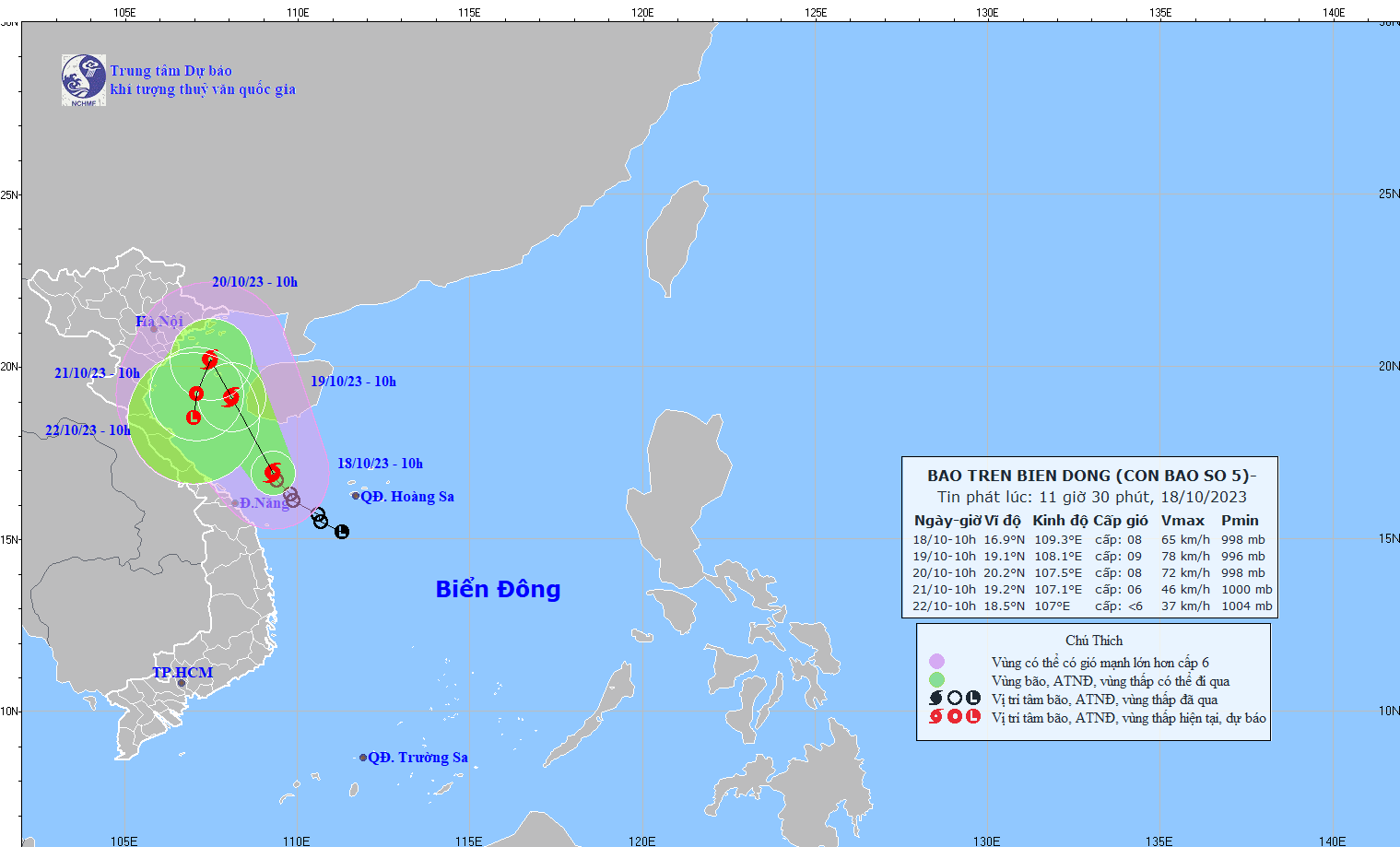
The new storm becomes the fifth one of 2023 in the East Sea..
 |
| The expected track of the new tropical storm (Source: NCHMF) |
Forecast models indicate that at 11:00am on Wednesday, the storm’s eye was spotted near latitude 16.9 North, longitude 109.3 East, about 270km west-northwest of Hoang Sa Islands, about 150km east of the mainland of the parts from Quang Tri to Quang Ngai. It was packing maximum winds of level 8 (62 - 74 kilometers per hour) near the center and gusts of level 11 as it moved north-northwestward at about 10 kilometers per hour over Vietnamese sea.
Environmental conditions are forecast to be conducive for development while the storm continues its north-northwest track at 15 kilometers per hour at about 10 kilometers per hour, and it is expected to grow even stronger.
At 11:00am on Thursday, the storm will be positioned near latitude 19.1 North, longitude 108.1 East, lie to east of the Gulf of Tonkin, with maximum sustained winds reaching levels at 8 to 9, and the gusts as high as level 12.
The danger area around the tropical storm is predicted to be located near latitude 15-21 North and longitude 111.5 East. Warning for strong winds, and big waves has been issued for all vessels operating in the danger area.
The national weather service has issued Natural Disaster Alert at level 3 for southwest of North East Sea, the Gulf of Tonkin, and the open waters off the Quang Tri - Quang Nam Coast.
At 10:00 a.m. on Friday, the storm will continue to track north-northwestward at 5 kilometres per hour, and it will be located near latitude 20.2 North, longitude 107.5 East, sit over the Gulf of Tonkin, with the maximum sustained winds reaching levels at 8, and gusts at level 11. National forecasters have issued a weather warning for strong winds and high waves to all vessels operating in the potentially dangerous area which is located near latitude 16.0 North, and longitude 110.0 East.
NCHMF has placed the Gulf of Tonkin, and the open waters off the Quang Tri - Thua Thien Hue Coast under Natural Disaster Alert at level 3.
The storm will then change its direction and move toward the south-southwest while gradually weakening back into a tropical depression. At around 10 a.m. on Saturday, the storm will be centered near latitude 19.2 North, longitude 107.1 East, sit over the Gulf of Tonkin, packaging maximum sustained winds reaching level 6, and the gusts as high as level 8.
The danger area around the tropical storm is forecast to be located near latitude 16.0 North and longitude 110.0 East.
The national forecasters have issued Natural Disaster Alert at level 3 for the Gulf of Tonkin.
The depression will likely tend to weaken gradually and is expected to continue to fizzle out over the next 72 to 96 hours as it tracks to south-southwest. Some uncertainty remains in the track and intensity forecast, and significant changes could occur in the coming days.
Under these conditions, the southwest of North East Sea, the open waters of the Quang Tri - Quang Nam Coast, including Da Nang, will see strong winds at levels 6 to 7. The maximum sustained winds reaching levels at 8 to 9, and the gusts as high as level 12 will affect areas near the storm’s center with rough seas.
From Wednesday night, the Gulf of Tonkin could see gradually increasing strong winds at levels 6 to 7 while the area near the storm’s center will experience high winds at levels 8 to 9, and gustiness of level 12 with rough seas.
Waves as high as 2-4m are expected to assail southwest of North East Sea (including the waters of the Hoang Sa Islands), and the open waters off the Quang Tri - Quang Ngai Coast.
Rough seas with waves as high as 2-4m, then increase to 3 - 5 m, are in forecast for the Gulf of Tonkin from early Thursday morning.
Moderate to heavy rain with isolated extremely heavy falls is likely over the parts from Quang Tri to Thua Thien – Hue from Wednesday afternoon into Thursday morning, after which, drier spells should prevail.
Coastal areas of the northern region, Southern Delta, and North Central Coast should prepare for moderate rain with isolated heavy to very heavy falls from Thursday night while the Mid-Central region is predicted to stay mostly free of rain from Thursday afternoon.
Reporting by BAOTINTUC- HOANG HIEP - Translating by H.L