Da Nang braces for cooler weather as temperatures set to drop to 19 degrees Celsius, new tropical depression likely to enter East Sea
A weather warning will be in place for the Mid-central region, including Da Nang as the region will experience cold and wet weather conditions from late Tuesday afternoon, December 19.
In a statement issued on Monday afternoon, the Mid-Central Region Centre for Hydro-meteorological Forecasting said that the chilly and windy conditions, as well as scattered moderate rain with localized heavy to very heavy falls are expected across the parts from Quang Binh to Quang Ngai, including Da Nang, from late Tuesday afternoon.
The regional weather service has attributed the cold weather to the influence of an intense cold snap.
Bitter cold temperatures are expected to strike the parts from Quang Binh to Thua Thien- Hue as the minimum temperature is predicted to drop to 13 to 15 degrees Celsius in Quang Binh, 15 to 17 degrees Celsius in Quang Tri, 17 to 19 degrees Celsius in Thua Thien- Hue, and even 14 to 16 degrees Celsius in their mountainous areas.
The parts from Da Nang to Quang Ngai will also come under the influence of intense cold wave as the minimum temperature is likely to settle in the range from 19-21 degrees Celsius, and even 17 to 19 degrees Celsius in their mountainous areas. The coolest temperatures are in the early morning and at night across these areas, regional forecasters warned.
Under these conditions, by the coastal areas of the Mid-central region they will see high winds at levels 4 to 5 and gustiness of levels 6 to 7, and farther inland you could find gradually increasing northeasterly wind at levels 3 to 4.
Strong northeasterly winds at level 7, and gustiness of levels 8 to 9, as well as rough seas with waves as high as 4-6m are in forecast for the waters of Hoang Sa Islands.
The open waters off the Quang Binh – Quang Ngai Coast could experience strong northeasterly winds at levels 6 to 7, and the gusts reaching levels 8 to 9, as well as rough seas with waves as high 3-5m.
Meteorologists at Viet Nam’s National Center for Hydro-meteorological Forecasting (NCHMF) continue to monitor a new tropical depression which has been downgraded from tropical Storm Jelawat (named "Kabayan" in the Philippines).
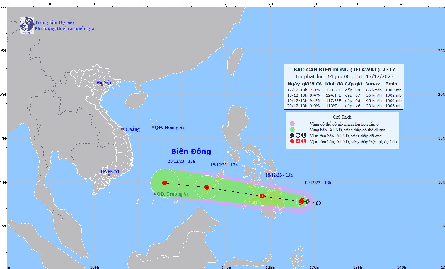 |
| The expected track of a new tropical depression which has been downgraded from tropical Storm Jelawat (Source: NCHMF) |
Jelawat formed over the southern Philippine Sea on 17 December, and it weakened to a tropical depression as it made landfall in Davao Oriental on Monday morning, December 18, NCHMF said in its latest advisory.
Forecast models indicate that at 7:00am on Tuesday, December 19, the depression's centre was spotted near latitude 8.1 North, longitude 122.8 East, lied to the southern Philippines. It was packing maximum winds of level 6 (39 - 49 kilometers per hour) near the center and gusts of level 8 as it moved west-northwestward at about 25 kilometers per hour over the Philippine Sea.
The depression is forecast to weaken further after making its way to the East Sea Tuesday night or early Wednesday morning.
At 7:00 a.m. on Wednesday, December 20, the system will continue to track west-northwestward at about 25 kilometers per hour, sit over the southeastern part of the East Sea. The depression will likely tend to weaken gradually and is expected to continue to fizzle out as it moves over the East Sea.
Due to the influence of tropical depression, waves as high as 2-4m are expected to assail the middle of the East Sea on Wednesday and Thursday.
During the forecast period, rough seas with waves as high as 3-5m, are in forecast for the Southern part of the East Sea.
National forecasters have issued a weather warning for strong winds and high waves to all vessels operating in the East Sea and the waters off the coast of mid-central and south central regions.
The depression is expected to bring rainfall to much of Central Viet Nam from Ha Tinh to Quang Ngai, including Da Nang from Tuesday afternoon and night, December 19
Moderate rainfall with isolated heavy to very heavy falls and thunderstorm chance is likely over these areas with the total rainfall amount expected to reach 15mm to 30mm in common, and even over 60mm possible in some places.
The parts from Quang Binh to Khanh Hoa, including Da Nang, will continue to experience light to moderate rainfall in most areas, with heavy rainfall and thunderstorms at isolated locations during daytime and night of Wednesday, December 20.
The national forecasters have issued alert of heavy rain, tornadoes, and lightning at level 1 for the affected areas.
Forecasters have issued warnings of flash floods and landslides for mountainous areas in the affected areas, and localized flooding alerts are in place in low-lying and urban areas. The advisory urges residents to ‘be aware’ of inclement weather. Residents in affected areas are advised to get ready for such weather conditions in an attempt to reduce the risk of possible damages.
Reporting by HOANG HIEP – Baotintuc - Translating by H.L