Preparedness for heavy rain, thunderstorms due to tropical depression
At 1:00 p.m on Monday, the centre of the tropical depression was at latitude 16°03'N and longitude 109°01'E along the central coast of Viet Nam from Quang Tri to Quang Nam provinces.
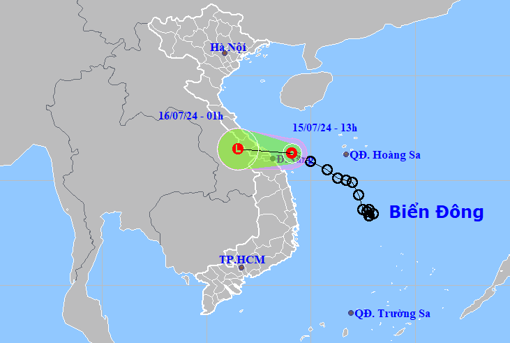 |
| The tropical depression's projected path. Photo: The National Center for Hydro-meteorological Forecasting |
The strongest winds near the centre of the tropical depression reached only level 6, with gusts of up to level 8.
In the next 12 hours, it is forecast to move west into the central coast at a speed of between 10-15kph and then gradually weaken into a low pressure zone, according to the National Center for Hydro-meteorological Forecasting.
At 1:00 pm tomorrow, July 16, the centre of the low pressure zone will be located at latitude 16°05'N and longitude 106°05’E in the southern Laos region with the strongest winds of below level 6.
Due to the influence of the tropical depression, offshore waters from Quang Binh to Quang Ngai provinces are experiencing showers and thunderstorms, strong winds of level 6 with gusts of level 8, rough seas, sea waves of 1.5-3m high. The Gulf of Tonkin has strong winds of level 5, sometimes level 6, rough seas, and sea waves 1.5-2.5m high.
Between July 15 and 17, the tropical depression is anticipated to bring heavy rain to northern Delta and coastal areas, and localities from Hoa Binh to Quang Tri, with a common rainfall of between 60-100mm. In some places, the rainfall is forecast to exceed 200mm.
Meanwhile, as much as 40mm-80mm of rain, even over 150mm, could fall in the Highlands region.
Reporting by HOANG HIEP - Translating by M.DUNG