Heavy downpours expected in central Viet Nam as storm set to hit
A tropical depression in the sea east of the Philippines has upgraded into a storm and is moving toward Viet Nam’s central coast, according to the National Centre for Hydrometeorological Forecasting.
 |
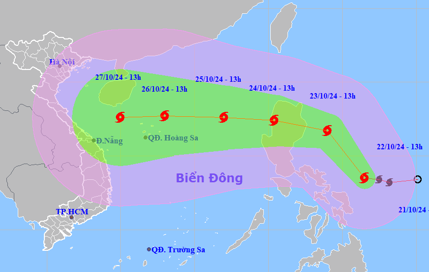
| The forecast path of storm Trami. Photo: National Center for Hydrometeorological Forecasting |
The storm, internationally known as Trami, was spotted at latitude 13°5'N and longitude 126°5'E in the sea east of the central Philippines as of 1:00 pm on Tuesday, packing strong winds of level 8, gusts reaching level 10. It is moving northwest at a speed of 15-20 km/h.
By 1:00 pm on October 23, Trami is forecast to be located in the sea east of Luzon Island (the Philippines) with the strongest wind force of level 9, gusting to level 11. The dangerous area at sea in the next 24 hours is from latitude 14-19 (north latitude), east of longitude 122 (east longitude).
In the next 3 days, the storm will change direction to move towards west at a speed of about 15 km/h and enter the East Sea.
By 1:00 pm on October 25, the centre of the storm will be at latitude 17°6'N and longitude 117°0'E, about 550 km east-northeast of the Hoang Sa Archipelago, carrying winds of level 11 and gusts reaching to level 14.
After that, the storm will move mainly in a westerly direction at a speed of 15-20 km/h and is likely to strengthen.
Due to the influence of the storm, the eastern area of the northern East Sea is experiencing strong winds of levels 6-7. In areas closer to the eye of the storm, waves may reach 6-8 meters high, winds will reach levels 10-11, and squalls will reach level 14, posing significant safety risks for vessels operating in the area.
Before the storm's arrival, heavy rains are expected to batter central Viet Nam due to the influence of the strengthening cold air from the night of October 22 to 23.
The localities from Nghe An to Binh Dinh are forecast to experience moderate to heavy downpours. During thunderstorms, there is a possibility of tornadoes, lightning, hail and strong gusts of wind.
In response to the imminent typhoon, the Ministry of Agriculture and Rural Development has sent an urgent telegram to local authorities and relevant ministries, calling for emergency measures.
Coastal provinces are urged to closely monitor weather reports and inform fishermen and vessels at sea to take necessary precautions. Plans to protect lives and property must be underway, with emergency rescue teams and communication systems on standby.
On land, the Ministry urges evacuation plans for those in high-risk areas. Additionally, local forces must be quickly deployed to ensure traffic safety in regions affected by floodwaters and landslides.
Critical infrastructure such as roads, bridges, and reservoirs, must be under close surveillance, with repair teams ready to respond to any incidents.
Reporting by HOANG HIEP - Translating by M.DUNG