Storm Trami likely to move close to central coast, causing heavy rain
As of 1:00pm on Friday, the storm No.6, internationally known as Trami, was located over the eastern area of the East Sea, about 560 km east-northeast of the Hoang Sa Archipelago, moving west-northwest at a speed of 15-20 kph, with maximum wind speeds reaching level 12, according to the National Centre for Hydro-Meteorological Forecasting.
 |
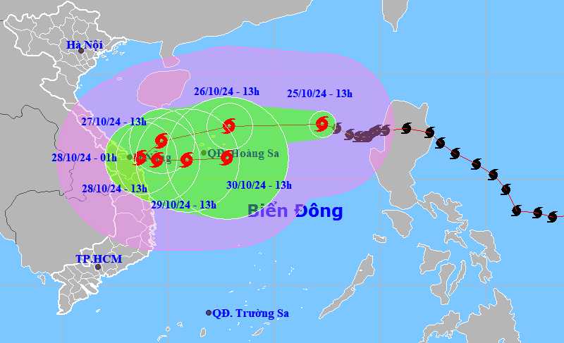
| The forecast path of storm Trami. Photo: National Center for Hydrometeorological Forecasting |
The centre predicts that by 1:00 pm on Saturday, the storm will be positioned at about 17.5 degrees north latitude, 112.9 degrees east longitude, in the Hoang Sa Archipelago, with intensified winds reaching up to level 15. The storm will march northwest at a speed of approximately 20 kph.
By 1:00 am on October 28, the storm’s centre will be at about 16 degrees north latitude and 108.7 degrees east longitude (near the coast of mid-central Viet Nam) with the strongest wind force of level 10, then will change direction to the east.
By 1:00 pm on October 28, the storm will be located at about 15.9 degrees north latitude, 109.5 degrees east longitude, in the coastal waters of mid-central Viet Nam with the strongest wind force of level 10, gusting to level 12. The storm will move mainly eastward at a speed of 5-10 km/h, and then will weaken.
Due to the influence of the storm, the northern area of the East Sea is experiencing strong winds of levels 8-9. In areas closer to the eye of the storm, waves may reach 5-7 meters high, winds will reach levels 11-12, and squalls will reach level 15.
Starting from October 27, the sea areas of provinces and cities from Quang Binh to Quang Ngai provinces (including Con Co and Ly Son island districts) will have rough sea. Sea waves are to reach heights of 5-7 meters, with the strongest wind hitting level 10-11 and gusts of level 14, posing significant safety risks for vessels operating in the area.
Vessels operating in the above-mentioned dangerous areas (especially in the Hoang Sa island district) are likely to be affected by storms, whirlwinds, strong winds, and large waves.
From October 26 to 28, localities from Quang Tri to Quang Ngai are forecast to experience heavy to very heavy rain with total rainfall ranging from 300-500mm, or over 700mm in some parts. The national weather service provides early warnings about localised heavy rain (intense rainfall of over 100mm/3 hours).
Ha Tinh, Quang Binh, Binh Dinh and the Northern Central Highlands could see heavy to very heavy rainfall of 100-300mm.
Reporting by HOANG HIEP - Translating by M.DUNG