The lifeline of a village
Ha Khe (Khe Sen), a babbling brook that runs through the heart of Ha Lam Village, has been deemed as the community's vital lifeline by the village’s ancestors. Currently, this once humble watercourse has blossomed into a core focal point within the development blueprint of the burgeoning town of Ha Lam.
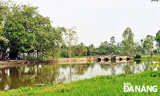 |
| A part of Ha Khe where the Ha Kieu Bridge crosses. Photo: L.T |
From the village to the town
Drawing on historical artifacts and archival documents, it's plausible to assert that the inception of Ha Lam Village, presently known as Ha Lam Town in the Thang Binh District, took place towards the close of the 15th century. The region's initial settlers are believed to have migrated from Ky Anh, Ha Tinh Province (formerly Ha Ba District, Nghe An), following King Le Thanh Tong's southern expedition in 1471.
In “Ha Lam xa chi”, a historical work curated by the Ha Lam Ancient Tribe Council in 2003, we learn that Vo Van Kham, an ancestor hailing from Nghe An town, founded the village around five centuries ago.
On his exploration mission, Kham discovered Ha Lam's uncultivated, picturesque landscape. Teeming with luxuriant trees, clear flowing water, and blossoming lotuses, the area was deemed ideal to settle. Together with his companions, they laid the settlement's groundwork, appropriately naming the area 'Ha Lam' from the phrase, 'Lam's fields, where gems unfold, Ha Ba's fragrance, tales untold'.
Citing the Nguyen Duc family genealogy, it details how their ancestor, Luong Xuyen, was inspired by the natural scenery. He observed lotus streams meandering through the terrain, illuminating the adjacent indigo-green rice fields. Moved by this pastoral elegance, he chose the fitting name of “Ha Lam”.
Intriguingly, despite its early establishment, this village fails to make a mention in antiquated records. Notably, in Duong Van An's “O chau can luc” (1553), as well as in Le Quy Don's “Phu bien tap luc” (1776), which meticulously lists villages, hamlets, and communes across all prefectures and districts, Ha Lam's name is surprisingly absent. However, we encounter a saving grace in the form of a section describing the region's geographical features, castles, headquarters, roads, harbors, and railway stations, where Ha Lam does receive a mention:: “..It takes a day to traverse through the communes of Huong Ly, Huong Loc, Huong Tuyen, Cat shop, Lieu Shop to reach Ha Lam Commune.
From Ha Lam, one can pass through Cay Mit Shop, Ba Tu Commune, Truong An Shop, Cam Lu Commune, Ke Xuyen, Tra Long, Lo Thoi, Loi and Thap shops to arrive at Chien Dan Day Market …” (Phu Bien tap luc, Science Publishing House, Hanoi, 1964, pg. 121).
It wasn't until the reign of the Nguyen Dynasty that Ha Lam Village found specific recognition. As stated in the land registry of the Nguyen Dynasty, compiled between 1812 and 1818, Ha Lam was noted as one of 29 villages encompassed the Phu My Trung Canton, Le Duong District, Thang Hoa District.
The village was defined by four distinct borders: The north touching Ngoc Son Commune and Lieu Tri Commune following the field edge; the south brushing against Phuc An Ward (part of Chu Tuong) and Cay Mit Village, the east sharing bounds with Cay Mit and Cay Son communes with the sandy beach as a natural separator; while the west ran up against Thanh Ly commune, Dong The village, and Phu Son Commune.
Tracing the lineage of Ha Lam's administrative affiliations after the August Revolution, it initially fell under Thang Hoa, Thang Chau, and Thang After 1954, the district was re-delineated and Ha Lam came under Binh Nguyen Commune.
Since 1984, Ha Lam Village was disengaged from Binh Nguyen and amalgamated with Dong Thai and Chung Phuoc villages to establish the modern Ha Lam Town, serving as the administrative center of Thang Binh district.
Ha Lam Village has had a storied history as the headquarters of the Thang Hoa (Binh) District. As mentioned in 'Dai Nam Nhat Thong Chi,' "The capital of Thang Hoa palace, surrounded by a 51 staff-circumference bamboo enclosure, was situated in Ha Lam village and constructed in the 2nd year of Minh Mang (1821)".
Ha Khe, the village's lifeline
Running its course through the heart of Ha Lam village is a natural water stream named Ha Khe - adorned with plentiful lotus flowers (Ha symbolizing lotus and Khe for stream).
During the inception of the Nguyen Dynasty and due to irrigation needs, the village officials rallied the community to construct a dam upstream and expand the creek bed to facilitate water flow from the Ly Ly River for watering village fields.
After renovations, Ha Khe broadened and took an intricate, winding form, reminiscent of a dragon, earning the name Cuu Khuc Ha Tri or Bau Sen Chin Doan.
Remnants of Ha Tri Cuu Khuc include a varied-width stream that stretches 7km, originating from the Ly Ly River, flowing through Binh Quy Commune, and bypassing National Highway 14B at Bon Thuoc Bridge before merging into Ha Lam Village. The stream passes Phuoc Nguyen Pagoda, crosses Ha Kieu Bridge before veering east.
After crossing National Highway 1A, it trickles into Ha Lam field and is channeled into Bau Bang (Binh Phuc) by a canal. This dam regulates the water source to prevent the Ly Ly river from drying in the dry season and flooding in the rainy season.
Elders in Ha Lam bear a firm belief that Ha Khe is not only a vital irrigation project that has brought prosperity at villagers' doorsteps and a scenic highlight in the village landscape, but also holds significant feng shui implications. The lotus-clad dragon-like Ha Khe, in times past, brought prestige to the village with a plaque awarded by the Tu Duc court inscribed with "Thien tuc kha phong" or "Good deeds." It further became a beacon of academic excellence in Viet Nam during the Confucian era, boasting of a roster which included 1 vice president (Nguyen Thuat), 5 bachelors (Nguyen Tao, Nguyen Uynh, Nguyen Chuc, Nguyen Huu Quang, Nguyen Huu Loc), and 18 baccalaureates, accounting for a whopping 20% of the district's faculty!
In 1890, Ha Kieu, a wooden bridge, was crafted between the Thi and Trung hamlets within the village area. A decade later, in 1900, the bridge underwent restorations for solidification. Marking this event, a stele was erected, which stands to this day, bearing testament to the village's transforming landscape.
Today, in the urban space development planning of Ha Lam Town, there is a tendency to expand to the South (on the right bank of Ha Khe). This has inadvertently split the town into two areas: the traditional area on the left bank, and the burgeoning new area on the right. Thus, Ha Kieu has emerged as the town's "central area" and "landscape area."
However, as we contemplate the feng shui significance of Ha Khe (also known as Ha Tri Cuu Khuc) – an indispensable component in the development blueprint for a district capital poised on the brink of intense growth – it's essential to focus on preserving a smooth flow for Ha Khe stream. It is crucial that both local government and the people concentrate on ensuring it remains unobstructed (avoiding bulldozing, silting, or drying out), and prevent water pollution.
Reporting by LE THI - Translating by HOAI TRANG