Tropical depression strengthens into storm, cloudy weather continues in city
According to the National Centre for Hydro-Meteorological Forecasting (NCHMF), a tropical depression has already strengthened into a storm, the 2nd of its kind this year, in the sea area northwest of the Hoang Sa Archipelago.
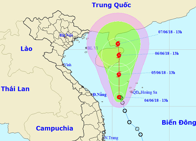 |
| The expected journey of the newly-formed storm (Photo: NCHMF) |
At 7.00am today, 5 June, the newly-formed typhoon was positioned at latitude 17°3’N and longitude 111°1’E, to the northwest of the Hoang Sa Archipelago, about 190km south-eastern of the Hainan Island in China, packing wind speeds of 60 - 75 kph (level 8) near its centre, and gusts of level 10.
Over the next 24 hours, the storm is forecasted to move northwards at a velocity of between 5 and 10 km an hour.
At 7.00am on Wednesday, the storm’s position was located at latitude 19°5’N and longitude 111°3’E, on the sea area off the eastern coast of the Hainan Island, packing gusts of level 11.
At 7.00am on Thursday, the storm’s position was identified at latitude 20°5’N and longitude 110°7’E, to the east of the Leizhou Peninsula in China.
Afterwards, the storm is predicted to continue its north - northwest journey at a speed of about 5 km per hour, and then weaken into a tropical depression.
At 7.00am Friday, the typhoon was positioned at latitude 21°3’N and longitude 110°3’E, with strongest winds near its centre estimated at 50 - 60 kph (level 7), and squalls of level 9.
According to the national forecasters, under the influence of the weather phenomenon, Da Nang is expected to continue experiencing cloudy weather over the next few days.
Sea waters off the coast of Da Nang are bracing for showers and thunderstorms, with waves from 1.5m to 3m high.
Meanwhile, strong winds level 6 - 7, with gusts of level 8-10, very heavy rough seas and waves from 2m to 4m high are being recorded in the Hoang Sa waters.