Wet weather continues in city as storm prepares to soak northern and central localities
According to the National Centre for Hydro-Meteorological Forecasting (NCHMF), a tropical depression has already strengthened into a storm, the 3rd of its kind this year formed in the East Sea, and it is heading towards northern and central localities.
 |
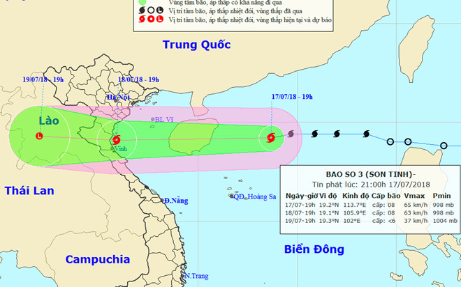
| The expected path of the ‘Son Tinh’ storm |
‘Son Tinh’, as the storm has been internationally named, was spotted to the northwest of the Philippines on Tuesday morning before it kept moving west towards Viet Nam with wind speeds of 75 km(47 miles) per hour.
It was around 350 km off the coast from Hai Phong port city to the north central province of Ha Tinh at 7.00am on Wednesday. Winds of up to 75 kph are expected to bring rough water and six-meter waves around the Hoang Sa (Paracel) Islands and the Gulf of Tonkin.
The storm is now keeping moving in the western direction at a velocity of between 25 and 30 km an hour.
At around 7.00pm today, 18 July, the newly-formed typhoon could head straight for localities from Hai Phong to Ha Tinh, packing wind speeds of 60 - 75 kph (level 8) near its centre, and gusts of level 10, carrying heavy rains and rough seas. Afterwards, it will weaken into a tropical depression again.
At 1.00am on Thursday, 19 July, the depression’s position is forecast to be at latitude 19°4’N and longitude 104°0’E, lying in a border area between Viet Nam and Laos.
According to the national forecasters, under the influence of the weather phenomenon, Da Nang is expected to continue experiencing moderate to heavy rain, and thunderstorms in some parts over the next few days.
Sea waters off the coast of Da Nang are bracing for seasonal southwesterly winds at levels 4-5 and sea waves from 0.5 - 1.5m high.
Meanwhile, showers and thunderstorms, strong winds level 8, with gusts of level 10, very heavy rough seas and waves from 3m to 5m high are being recorded in the Hoang Sa waters.
As initiate urgent measures to cope with the affects of the typhoon, Da Nang’s border guards and the municipal Coastal Information Station are jointly maintaining around-the-clock contact with local fishing boats operating offshore in order to keep them well informed of the storm’s position and movement, hereby avoiding any unexpected incidents. These boats are leaving dangerous waters and moving to safety.
In another movement, torrential rains triggered by the influence of the inter-tropical convergence zone combined with a subtropical ridge are predicted to continue hitting Hoa Binh, the northern delta provinces and localities from Thanh Hoa to Thua Thien Hue until Friday.
Another tropical depression is moving close to the coast of central provinces from Nghe An to Quang Binh with maximum speeds of 50 kph, bringing heavy downpours and gusty winds to the region.
According to the national weather experts, a total of 8 to 10 storms and tropical depressions could hit the East Sea this year.


