Tropical depression expected to become storm in East Sea, bringing widespread downpours across Da Nang
A freshly-formed tropical depression in the northern part of the East Sea is likely to develop into a storm in the coming time, accompanied with the low pressure trough developing through the northwest-southeast axis, Viet Nam's National Centre for Hydro-Meteorological Forecasting has warned. As a result, widespread rain will sweep across localities from Quang Binh to Quang Ngai, including Da Nang, in the days to come.
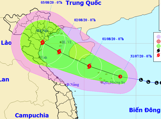 |
| The expected track of the tropical depression which is likely to strengthen into a storm (Source: The National Centre for Hydro-Meteorological Forecasting) |
At 7:00am today, the tropical depression’s position was located at latitude 16°8'N and longitude 113°5'E, about 160 km east of the Hoang Sa (Paracels) Island.
The strongest wind speed near its centre was 40-60kph at levels 6-7, with a gust of level 9.
Over the next hours, the tropical depression is forecast to move in a west- northwest direction at a velocity of 10 - 15 km an hour, and increase its intensity to develop into a storm later.
At 7:00am on 1 August, the soon-to-be-formed storm’s centre is predicted to be about 100km southeast of Hainan Island (China) with the strongest wind of level 8, a gust of 10, and maintains its aforementioned velocity.
Due to the strong influence of the storm, the northern part of the East Sea will be likely to embrace for heavy thunderstorms, strong winds levels 6-7, a gust of level 10, sea waves from 3 to 5 m high, and rough seas.
The same wind levels, rough sea, and sea waves to a height of up to 4m will occur in the middle and southern parts of the East Sea, including the Truong Sa (Spratly) Islands, and the waters off the coast of southern localities from Binh Thuan to Ca Mau, including the Phu Quy Island.
All fishing vessels operating in these serious waters might be affected by possible gusts and tornadoes.
In order to proactively respond to tropical depression and possible widespread heavy downpours, Viet Nam's National Steering Committee for Natural Disaster Prevention and Control is urging the authorities of coastal localities to inform their fishing boats of the predicted movement of the tropical depression, hereby allow them to take the initiative to avoid dangerous areas or seek safe shelters.
From 1 to 3 August, localities from Quang Binh and Quang Tri will embrace for moderate to torrential rain.
Meanwhile, the lower rainfall is possible in localities from Thua Thien Hue to Quang Nam, including Da Nang, with scattered moderate rain reported in many of their places.
Regional weather forecasters say most parts of Da Nang will get soaked with showers and thunderstorms, with its thermometers dipping between 25 to 33 degrees Celsius. The average humidity is reported as around 59%.
By HOANG HIEP – Translated by A.T