Tropical depression forms in East Sea, with more development likely
A tropical depression has formed in the East Sea and is expected to strengthen into a tropical storm, Viet Nam's National Centre for Hydro-Meteorological Forecasting has said.
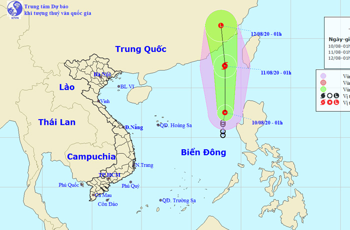 |
| The expected track of the tropical depression which is expected to strengthen into a storm (Source: The National Centre for Hydro-Meteorological Forecasting) |
At 1.00am today, 10 August, the centre of the tropical depression was located at latitude 17°5'N and longitude 118°4'E, about 180 km west of the Luzon Island in the Philippines.
The tropical depression currently has the maximum sustained winds of 40-60kph at levels 6-7, gusting up to level 9.
The tropical depression is moving in the north direction with a speed of 20 - 25 km/ hour, and gradually gain strength. Models are simulating it could eventually be upgraded into a tropical storm over the next 24 hours.
At 1.00am on 11 August, the centre of the soon-to-be-formed storm will be located at latitude 22°2'N and longitude 118°4'E, about 200 km southwest of Taiwan, with the strongest wind of level 8.
Due to the strong influence of the storm, the northern and central parts of the East Sea will be likely to embrace for heavy thunderstorms, strong winds levels 6-7, a gust of level 10, sea waves from 3 to 5 m high, and rough seas.
Additionally, under the influence of the ongoing tropical depression associated with strong southwest monsoon winds and inter-tropical convergence zone, some coastal localities in south central coastal and central regions in Viet Nam will be likely to experience heavy to very heavy downpours, and possibly thunderstorms tonight. The thunderstorms might result in lightning, whirlwinds, and strong winds.
By Bao Tin Tuc - Translated by M.D