Intensifed storm Molave enters East Sea, could threaten Da Nang – Phu Yen on 28 Oct
Flooded Central Viet Nam may has zero respite as it is forecast to continue bracing for fresh tropical storm Molave formed off east coast of central Philippines. The storm entered the East Sea this morning and forecast shows the storm making landfall anywhere from Da Nang to Phu Yen in the coming days, according to the National Centre for Hydro-Meteorological Forecasting latest weather warnings.
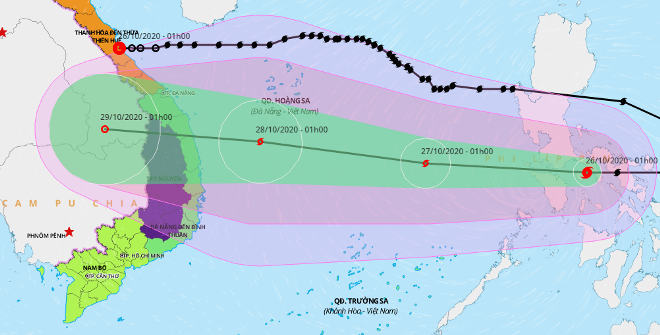 |
| Storm Molave‘s expected track (bottom line) and that of the tropical depression degrading from storm Saudel (top line) (Source: Viet Nam Disaster Management Authority (VNDMA), |
At 1 am today, 26, storm Molave hit Central Philippines, packing the maximum sustained winds of levels 11-12 near its eye, with a powerful gustiness of level 14.
Molave will be the ninth storm landfall over Viet Nam this year and the fourth hitting the country in October after Linfa, Nangka, Saudel. October, therefore, could see four tropical storms and one tropical depression, as happened in October 1993, the month with the most storms and tropical depressions in Vietnamese recorded history.
At 1 am on 27 October, the centre of Molave is expected to be about 350km northeast of the Song Tu Tay Island, carrying maximum winds of level 12, and a gale of level 14.
At 1am on 28 October, Molave’s eye may be located at near latitude 14°5’N and longitude 111°3’E, about 240 km east of the coast off central provinces from Quang Nam to Phu Yen, accompanied by with maximum wind levels of 12-13, and a gust of level 15.
Both Vietnamese and international weather forecasters similarly say storm Molave is set to whip Central Viet Nam coastline from Da Nang to Phu Yen, in the afternoon of 28 October, packing maximum sustained winds of level 12, and a gale of level 14.
After hitting Central Viet Nam, storm Molave is then likely to weaken into a tropical depression. Early on 29 October, the depression could sweep across southern Laos, with the wind intensity falling to only level 6, and a gust of level 8.
Storm Molave combined with a cold front could bring heavy rain threat to some parts of Central Viet Nam from Thua Thien –Hue to Quang Ngai, including Da Nang from 28 into 31 October, national weather forecasters said.
Meanwhile, storm Saudel weakened into a tropical depression early this morning before starting to hit central Viet Nam.
At 7 am on Monday, the depression whipped across southern Laos with maximum wind speeds of below 40 kph. Over the coming hours, the depression could continue losing its strength and becoming a post-tropical remnant low.
This weekend and subsequent days, Da Nang is forecast to see cloudy and soaking weather with scattered showers. Its thermometers should gradually dip between 23 to 27 degrees Celsius in the daytime, and turn a bit chilly in the night time.
By HOANG HIEP – Translated by A.T