Storm Saudel at lower level when hitting south of Tonkin Gulf, floodwaters slowly receding in Central Viet Nam
Tropical storm Saudel is forecast to be at lower level when hitting the south of the Gulf of Tonkin on Sunday, 25 October, with a gale of level 11, the National Hydrology Meteorology Forecast Centre (NCHFM) said.
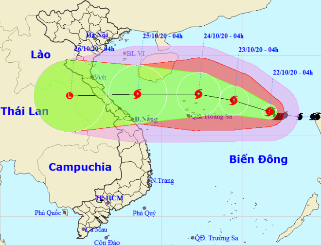 |
| Storm Saudel tracking map between 22 -26 October (Source: The National Hydrology Meteorology Forecast Centre) |
At 4am on Friday, 23 October, the centre of Saudel is expected to be located about 220 kilometers east-northeast of the Hoang Sa (Paracel) Archipelago with maximum sustained winds near its centre at 100-135 kph (levels 11 -12), and a gale of level 14.
In the next 24 hours, the storm is likely to remain its intensity as it hits the Hoang Sa islands, and may continue moving westwards to the East Sea at around 10-15 kph.
At 4am on Sunday, 25 October, Saudel’s eye should be positioned right on the south of the Gulf of Tonkin with maximum sustained winds near its centre at levels 8 -9, and a gale of level 11. In the next 72 and 96 hours, Saudel’s movement direction will be kept unchanged at a velocity of about 20 -25 kph.
As of Wednesday, a total of 52,598 offshore vessels had been well informed about the developments of the storm so that they can steer clear of the dangerous zones at sea, according to data publised by the Central Steering Committee for Natural Disaster Prevention and Control.
Under the impact of Saudel, the waters off Da Nang are experiencing scattered showers accompanied by thunderstorms, strong gale of level 7, sea waves from 2 to 3.5 m high, and very rough seas.
 |
| Floodwaters spilled over a residential area in Hoa Tien Commune, Hoa Vang District on Wednesday evening |
 |
| A flooded section of the DH 409 road in Hoa Tien Commune, Hoa Vang District on Wednesday evening |
Over the coming days, the city’s mercury is likely to witness a slight drop to only 23 – 29 degrees Celsius in the daytime, promising for cooler days ahead.
Thanks to the milder rainfalls, floodwaters on Kien Giang River in Quang Binh Province Thu Bon and Vu Gia rivers in Quang Nam Province and others in Thua Thien - Hue Province are keeping their downward trends.
On Thursday morning, the water level of Yen River upstream of the An Trach Dam stood at 4.64m, 0.36m lower than that reported on Wednesday evening. Floodwaters have also slowly receded from in paddy fields, low-lying and riverside areas, roads in Hoa Tien Commune, Hoa Vang District.
By HOANG HIEP – Translated by A.T