Molave forecast to introduce hurricane-force winds threat across Central Viet Nam on Tuesday evening
While moving towards Central Viet Nam, typhoon Molave is rapidly intensifying and is expected to introduce a hurricane-force winds threat across the region from Tuesday evening, according to the National Centre for Hydro-Meteorological Forecasting (NCHMF) latest warnings.
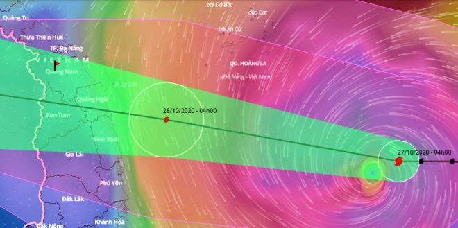 |
| Storm Molave tracking map (Source: General Department of Disaster Prevention and Control |
At 6 am on Tuesday, 27 October, the storm lay centred around about 222 km northeast of the Song Tu Tay Island, carrying maximum winds of level 14, and a gale of level 17.
Typhoon Molave will gradually pick up speed as it continues moving the west - northwest with winds of 20kph - 25kph in next 24 hours.
At 4am on Wednesday, 28 October, Molave’s eye could be located at near latitude 14°6’N and longitude 110°3’E, and Molave will reach the area of sea of Central Viet Nam, with maximum wind levels of 13 - 14, and a gust of level 17.
Typhoon Molave will keep its velocity unchanged. Severe damaging winds and torrential rainfall are expected along with the rapidly developing storm, moving into some parts of Central Viet Nam from Da Nang to Phu Yen.
After whipping across Central Viet Nam, Molave is then likely to weaken into a tropical depression. At 4am on 29 October, the depression could hit eastern Thailand, with the wind intensity falling to only level 6, and a gust of level 8.
Starting from Tuesday noon, the area of sea from Da Nang to Phu Yen, including Ly Son island district, will suffer strong winds of levels 9-11, then rise to levels 12 - 13, with a gust of level 15, along with fierce rough sea and 6m - 8m high sea waves .
Molave could bring wet and windy weather across central coastal localities from Thua Thien-Hue to Phu Yen, including Da Nang. Very heavy rainfall will spread across the area with a risk of flooding with the total rainfall of 200mm - 400mm, whilst North Central Highlands will brace for rain accumulation measuring 100mm - 200mm.
Heavy rain overnight Tuesday into Wednesday will turn heavier and more persistent through Wednesday.
In an advisory issued on Monday, NCHFM warned residents in at-risk locations to be highly vigilant against the upcoming disaster.
In his fresh urgent instruction, Vietnamese Prime Minister Nguyen Xuan Phuc affirmed, “Troops must deploy full force to support people, including mobilising helicopters, tanks and other necessary means of transportation if needed,”
Previously, Molave lashed the Philippines overnight causing heavy flooding, landslides, and leaving at least a dozen fishermen missing at sea on Monday.
By HOANG HIEP – Translated by A.T