Storm Saudel on its way to Central Viet Nam
Viet Nam’s National Steering Committee for Natural Disaster Control has issued a weather warning covering the next four days, warning of the freshly-formed storm Saudel for Central Viet Nam which is experiencing widespread flooding following heavy rains over the past nearly two weeks.
 |
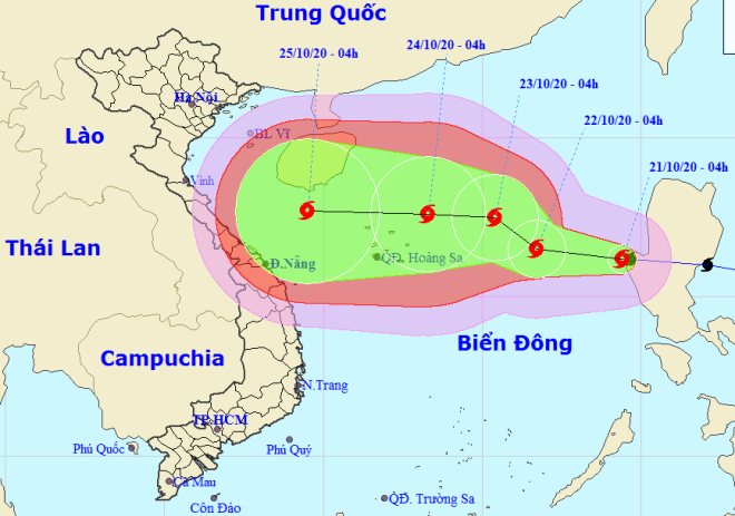
| Storm Saudel tracking map between 21- 25 October (Source: The National Hydrology Meteorology Forecast Centre) |
At 1pm on Wednesday, the center of Saudel is forecast to be located about 650 kilometers south-southeast of the Hoang Sa (Paracel) Archipelago, with sustained wind speed of levels 8 – 9, and a gust off level 11.
The storm will continue moving west-northwestward to the East Sea at around 20-25 kph, the National Hydrology Meteorology Forecast Centre (NCHFM) said.
At 1pm am on Friday, 23 October, Saudel is set to hit the Hoang Sa Archipelago, packing maximum sustained winds of level 11, and a gale of level 14.
Noticeably, the latest data on Saudel’s current trajectory suggests it is heading towards Central Viet Nam, though it has yet to be confirmed whether it would make landfall or even affect this region.
Meanwhile, the Japan Meteorological Agency recently anticipated Saudel’s eye would be close to the coastline of Central Viet Nam at around 7 am on Sunday, with a maximum wind speed of around 83 kph.
Likewise, the Hong Kong Observatory predicted the storm’s centre would approach to the region’s coast at around 8 am on Sunday, classified as a severe tropical storm with a maximum wind speed of 90 kph.
If Saudel does enter the East Sea, it would be the eighth storm to appear here this year.
Under the influence of the fresh storm combined with a cold front, some parts of central Viet Nam from Quang Tri to Quang Ngai, including Da Nang, is being get heavily soaked by the unpleasant wet weather with stretches of moderate to heavy downpours. It is not until tonight the rain may gradually decrease, national weather forecasters said.
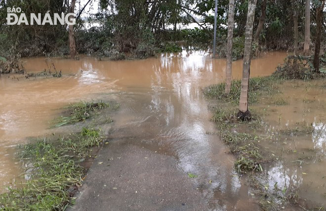
On Wednesday morning, a number of low-lying roads in Hoa Tien Commune, Hoa Vang District were flooded again.
The incident was attributed to the water levels on Vu Gia River swelling up on the upward trend, due to the floodwater discharge from the spillways of upstream hydropower reservoirs
 |
| A flooded low-lying road in Hoa Tien Commune, Hoa Vang District |
In a dispatch issued on Tuesday, the National Steering Committee for Natural Disaster Control urged governments of localities nationwide to keep up with the latest Saudel watches and warnings with NCHFM, in order to quickly inform vessels operating at sea about the approaching storm so that they can steer clear of the dangerous zones at sea.
Saudel may pose a big threat to parts of Central Viet Nam which have already been devastated by historic floods triggered by 30-year record rainfall of up to 3,000 mm in the past 10 days.
Between 6 and 19 October, the death toll in Viet Nam rose to 106, with 27 others still missing.
The flooding has isolated many communities and affected the lives of more than 135,000 households, destroyed 12 highways and 17.4 km of local roads; damaged 924 ha of rice and 106,616 ha of other crops, and killed or washed away more than half a million heads of cattle and poultry.
The International Federation of the Red Cross (IFRC) in a statement said the floods had compounded the suffering of people already struggling from the impacts of the coronavirus pandemic.
“These floods are the last straw and will push millions of people further towards the brink of poverty,” Christopher Rassi, Director of the Office of the Secretary General.
By HOANG HIEP – Translated by A.T