Widespread showers forecast for Da Nang into weekend
A low pressure system formed in the East Sea brought heavy downpours to most parts of Da Nang from Tuesday, and low pressure will dominate the Da Nang weather front for the remainder of the week, Viet Nam’s National Centre for Hydro-Meteorological Forecasting has warned.
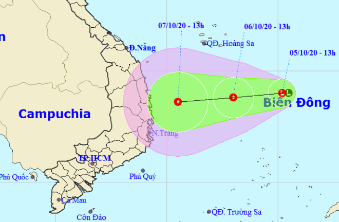 |
| The expected track of the depression (Source: The National Centre for Hydro-Meteorological Forecasting) |
Forecasters say the low pressure is moving mainly west at a velocity of about 10 kph, and it is likely to develop into a tropical depression.
At 1.00pm today, 6 October, the depression is predicted to be located about 400 km to the east of the coast of Binh Dinh - Khanh Hoa provinces, packing strong winds at levels 6-8 near its centre with a velocity of 40-60kph.
The depression will continue moving west at the speed of 10 kph, and it is predicted to gradually gain strength.
Due to the strong influence of the possible depression, the southern part of the East Sea will be likely to brace for strong winds levels 6-7, a gust of level 8, sea waves from 1.5 to 3m high, and rough seas.
From Wednesday into Saturday, residents in Da Nang, and elsewhere in the mid-central region, are expected to see wet weather and cooler temperatures. A total rainfall accumulation of 300 - 500mm is predicted to be recorded in these localities, with even between 500 and 700mm in coastal provinces of Ha Tinh - Da Nang.
Meanwhile, heavy showers are forecast for north highlands provinces from Tuesday and the wet weather will continue into this weekend, with a risk of thunder and lightning and stronger winds.
By HOANG HIEP - Translated by M.D