Storm Goni: Da Nang set to be battered by heavy rain from Wednesday through Friday
Parts of Da Nang and elsewhere in Central Viet Nam could be hit by heavy rain from Wednesday into Friday as storm Goni is making its way to south central Viet Nam shores, leading to the chance of flooding and also landslides across the region, Viet Nam's National Centre for Hydro-Meteorological Forecasting has warned.
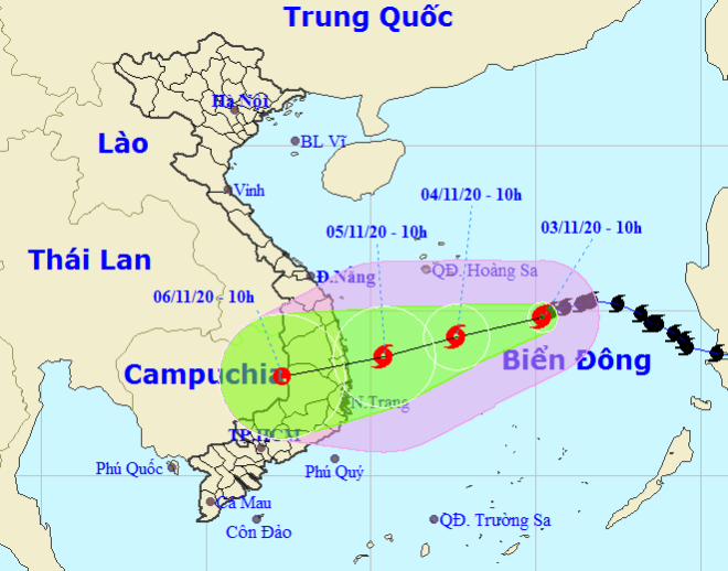 |
| Storm Goni tracking map (Photo: NCHFM) |
Widespread soaking weather is thought to result from the combined impact of Goni and northeast monsoon wind, NCHFM said.
Goni could continue moving the west-southwestward at 10 -15 kph, and it could weaken into a tropical depression before hitting the region from Quang Ngai to Khanh Hoa on Thursday, and continue to considerably downgrade its intensity, the national weather service said.
Binh Dinh, Phu Yen and the northern part of the Central Highlands are set to be battered by 100-200 mm of rain forecast from Wednesday into Friday. As much as 300-400mm of water could fall in the region from Thua Thien-Hue to Quang Ngai.
From Thursday into Saturday, the region from Nghe An to Quang Tri could experience 150-300mm of rain.
Da Nang will be soaked with 150-300mm of rain over the next three days, even over 350mm in some parts.
Mandatory evacuations will be ordered for people in the areas of Da Nang most at risk of flooding and landslides, given the fact that staying home to protect their property is not worth risking their safety.
Such these at-risk areas include the banks of Cu De and Tuy Loan rivers, the mountainous and midland communes of Hoa Son, Hoa Ninh, Hoa Bac, Hoa Phu and Hoa Lien, and along DT 601 and 14G streets in suburb Hoa Vang District, plus paths leading to the Son Tra Peninsula and Ba Na - Nui Chua special-use forest.
Also, Da Nang fishing boats are not being allowed to head out to sea, and relevant agencies are being asked to keep in close contact with boats currently operating at sea in order to handle any unexpected incidents during the storm’ wrath.
Given the impact of the storm, fishermen are highly advised to stay updated on the latest Goni watches and warnings issued by NCHFM, as well as to observe the appearance of the sky and the ocean surface to predict changes in weather. On being notified of a storm, they should steer their boats towards the mainland or far away from at-risk areas.
Water levels could reach alert level 3 in rivers in Quang Nam, Quang Ngai, exceed alert level 2 in the region from Nghe An to Thua Thien-Hue, Binh Dinh, Phu Yen and the Central Highlands provinces of Gia Lai and Kon Tum.
By HOANG HIEP – Translated by A.T