Da Nang takes radical solutions to alarming coastal erosion
Da Nang relevant agencies are gearing up taking remedial measures to deal with the existing coastal erosion areas in Son Tra and Ngu Hanh Son districts, the concerning issue posing an immediate threat to the urban face and causing seaside buildings to suffer from subsidence and structural damages. Meanwhile, prestigious domestic experts have made constructive recommendations for long-term solutions to protect the seashore of the city.
 |
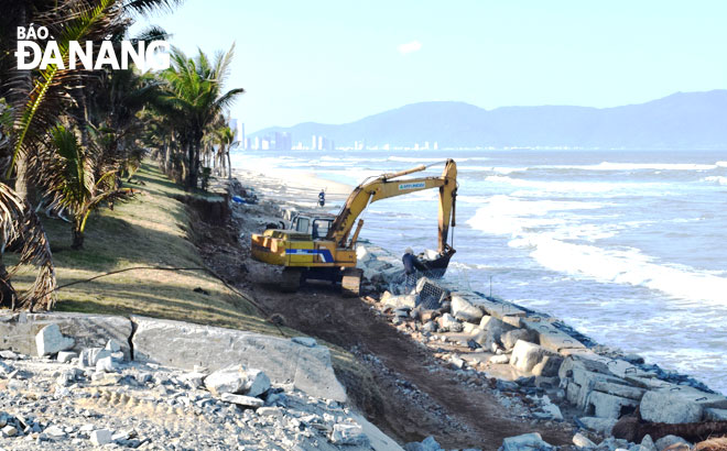
| The fortification of the stone embankment along Ngu Hanh Son District-based Son Thuy Beach is underway |
Six coastal erosion-hit areas needing to be solved
According to Viet Nam's national Department of Natural Disaster Response and Recovery, from 2015 to 2020, an around 30km –long stretch of the Da Nang coastline saw 12 erosion and land subsidence locales with a total length of 8.47 km, and all of them have been resolved.
Currently, six sections of the coastline stretching a length of about 0.57 km are under grave threat from coastal erosion.
The six erosion-hit coastal areas are a swimming area opposite the intersection of the Ho Thau - Vo Nguyen Giap streets, a site located behind restaurants Phuoc My 2 and My Hanh, a coastal section stretching from the intersection of the Vo Van Kiet and Vo Nguyen Giap streets to the front of the Grand Tourance Hotel, a vast running from beach No 9 to the Muong Thanh Hotel, a beach opposite the junction of Vo Nguyen Giap and Hoang Ke Viem streets, and Son Thuy Beach.
Causes and solutions to the phenomena of coastal erosion
The phenomenon appeared in 2017 and 2018 along these coastal areas, and it has resumed its impacts from late December 2020 up to now.
Deputy Director of the Da Nang Department of Natural Resources and the Environment of Vo Nguyen Chuong blamed such extreme weather matters as storms, tropical depressions, intensified cold air-triggered strong winds and heavy rough seas, storm surge, rising sea-levels and northeast monsoon directly affecting the coast off Da Nang for the alarming phenomena of coastal erosion.
Mr Chuong remarked that a vast coastal area stretching from the Son Tra Peninsula to the border with Quang Nam Province is vulnerable to seasonal variation of morphology and sediment movement.
Simply put, during the strong northeast monsoon season, this area usually braces for coastal erosion, but in the southwest monsoon season, sea waves carry sand onshore again.
Fully concurring with Chuong’s assessments, Huynh Van Thang, a member of the Executive Board of the Da Nang Environment and Nature Protection Association cum expert of the Coordination Board for integrated watershed and coastal management in Vu Gia – Thu Bon River Basin and Quang Nam - Da Nang coastal areas, viewed strong northeast monsoon as the ‘major agent’ for the raging coastal erosion over recent times in Da Nang, and the central coastal region at large.
“The stronger the northeast monsoon is, the higher the degree of coastal erosion is” affirmed Thang.
 |
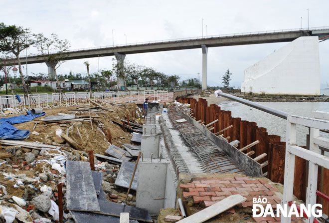
| A section of the embankment along the Nhu Nguyet riverside route’s pavement, heavily damaged by a storm-triggered strong waves in 2020, is being repaired. |
In particular, the 2020 – 2021 stormy season has seen many very strong typhoons and the rampage of northeast monsoon in Central Viet Nam, which led to inevitable and highly concerning matters such as erosion and land subsidence.
For the time being, focus is placed on accelerating the progress of works on new stone embankment segments to replace for sea waves-heavily destroyed ones during the 2018 - 2020 period at areas southern of the Son Thuy Beach, Hoa Hai Ward, Ngu Hanh Son District, and taking measures to prevent seawater from further encroaching onto land.
Likewise, warning signs have been placed at erosion-ravaged areas in order to ensure the ultimate safety of local residents and tourists.
In light of the complicated climate change-triggered global sea level rise, long- term solutions should be taken for the coastline protection, domestic experts recommended.
As one of the proper solutions, it is high time for the Da Nang authorities to map out plans to establish a coastal protection corridor in the city to minimise and adapt to the impacts of coastal erosion, climate change and sea level rise.
In order to set up the coastal protection corridor, tasks must be fulfiled on collecting information to assess natural conditions, natural resources, ecosystems, natural landscapes, cultural heritage, the plans for socio-economic development, the exploitation of natural resources, the actual state of the sea environment, and disaster risks in coastal areas.
Showing the same point of view, Deputy Director of the national Department of Natural Disaster Response and Recovery Nguyen Van Hai hailed central coastal localities for proactively implementing many structural and non-structural solutions to prevent coastal erosion.
In particular, groynes erected along beaches in the south central coastal provinces of Khanh Hoa and Phu Yen have proved highly effective in interrupting wave action and protecting the beaches from being washed away by longshore drift.
Likewise, an underground dyke stretch to reduce the impact of waves on the Cua Dai beach in Quang Nam Province’s Hoi An, and sloping embankments along beaches in the mid-central coastal localities of Quang Tri and Thua Thien- Hue have operated stably and effectively.
By HOANG HIEP- Translated by A.T


