Depression strengthens into tropical storm CEMPAKA
A tropical depression in the southwest of Hong Kong (China) has intensified into a tropical storm, the third one so far this year, and it was given the international name CEMPAKA, according to Viet Nam’s National Centre for Hydro-Meteorological Forecasting.
 |
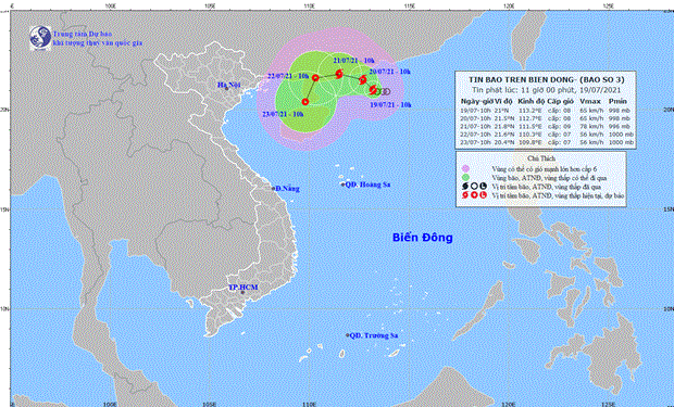
| The expected track of CEMPAKA (Source: The National Centre for Hydro-Meteorological Forecasting) |
In its latest bulletin, the National Centre for Hydro-Meteorological Forecasting said CEMPAKA now has maximum sustained winds of 60-75 kilometers per hour and gustiness of up to level 10.
At 10:00 am on Monday (July 19), the storm’s centre was located near latitude 21° 'N and longitude 113°2'E, about 180km southwest of Hong Kong (China). CEMPAKA is slowly moving toward the northwest.
At 10:00 am tomorrow (July 20), the storm will be positioned near latitude 21°5 'N and longitude 112°7'E, about 190km southwest of Hong Kong (China) with the maximum sustained winds reaching level 8, and the gusts as high as level 10.
In the next 24 hours, the danger area in the East Sea Sea around the tropical storm which is located at latitude 19°5'N and longitude 111°5'E- 114°5'E, could see strong winds at level 6, and the gusts as high as level 8 or higher. Warning for strong winds, big waves and tornadoes has been issued for all vessels operating in the danger area.
At 10:00 am on Wednesday (July 21), the storm is expected to change its direction to move toward the west-southwest at about 5km per hour and then weaken into a tropical depression.
At 10:00am on Thursday (July 22), the system’s center will be positioned near latitude 21°6'N and and longitude 110°3'E, right on the mainland southwest of Guangdong province (China) with the maximum sustained winds reaching level 7 (50-60 kmph), and the gusts as high as level 9.
The storm is likely to change its direction to move toward the south-southwest at 5km per hour. Warning for level 3 natural disaster risk has been issued for the northern part of the North East Sea.
The northern part of the Northern East Sea will see strong winds at level 6-7, and the gusts as high as level 10.
The offshore area stretching from Binh Thuan to Ca Mau, the area between the East Sea and the South of the East Sea will see gradually increasing the southwest wind at level 5-6, and the gusts reaching level 7-8, and experience rough seas with waves as high as 2-3m.
Reporting by TTXVN – Translating by H.L


