
Instensifying Storm Ma-on expected to enter East Sea on Wednesday
The tropical depression in the east of Luzon Island, Philippines was intensified into a tropical storm on Monday and it was named Ma-on, according to Viet Nam’s National Center for Hydro-meteorological Forecasting (NCHMF).
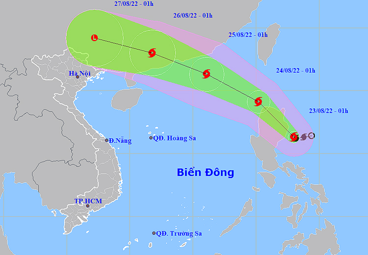 |
| The expected track of Ma-on (Source: NCHMF) |
Forecast models indicate at 1:00pm on Tuesday, August 23, the storm’s center will be located in the northwest of Luzon Island, Philippines, with the maximum sustained winds reaching level 8, and gustiness of level 10.
After making landfall as a tropical storm near Palanan in Isabela Province, Philippines, early Tuesday, August 23, Ma-on will likely continue to strengthen slightly as it tracks west- northwest at about 15 - 20 kilometres per hour. Environmental conditions are forecast to be conducive for development while the storm is likely to enter the northeastern part of the East Sea on Wednesday, and it is expected to grow even stronger.
At 1:00pm on Wednesday, August 24, the storm will be centred about 550km southeast of Hong Kong, China with the maximum sustained winds reaching level 9, and gustiness of level 11.
At 1:00am on Thurday, August 25, the storm’s center will be positioned near latitude 21°3'N and longitude 116°1'E, about 240km southeast of Hong Kong, China. The area near the storm’s center will experience high winds at level 10 (89-102 kilometres per hour), and gustiness of level 13.
Over the next 48 to 72 hours, Ma-on will continue to move toward the west- northwest at about 20 kilometres per hour.
At 1:00am on Friday, August 26, the storm's center will be located near latitude 23°N and longitude 111°8'E , right on the mainland of Guangdong Province, China. The maximum sustained winds reaching level 8 (62-74 kilometres per hour), and the gusts as high as level 10 will affect areas near the storm’s center.
From Tuesday afternoon, due to the influence of storm Ma-on, the Northern part of the East Sea will see increasing strong winds at levels 6 to 7, and then increase to level 8 while the area near the storm’s center will experience high winds at level 9, and gustiness of level 12 with rough seas and waves as high as 4m to 6m. A warning for level 3 natural disaster risk has been issued for the Norther part of the East Sea.
Over the next 72 to 96 hours, the storm will continue moving west-northwestward at 20 kilometres per hour and then weaken into a tropical depression after making landfall as a tropical storm over central Guangdong Province. It will then dissipate over eastern Yunnan Province on early Saturday, August 27.
The National Steering Committee for Natural Disaster Prevention and Control has urged authorities in coastal parts from Quang Ninh to Quang Ngai, including Da Nang, to take proactive and necessary mitigation measures in response to the tropical storm Ma-on.
The authorities in the warning areas must keep a close watch on severe weather development, and keep owners of vessels operating at sea timely informed about severe weather conditions in order to help them take the initiative to avoid dangerous areas or seek safe shelters during the bad weather. The focus must be on making the resources available in order to organize timely rescue of any person in distress at sea and provide timely support for those who need it during severe weather.
Reporting by HOANG HIEP- Baotintuc – translating by H.L