National weather service issues level 10 warning for storm Ma-on, showers with thunderstorms expected over South Central Coast, Central Highlands, Southern region until Friday
According to Viet Nam’s National Centre for Hydro-Meteorological Forecasting (NCHMF), showers with thunderstorms are expected to occur in South Central Coast, Central Highlands, and Southern region during daytime and night hours on Wednesday. National forecasters indicate heavy rainfall of 10 mm to 30mm, and even in excess of 50mm at isolated places in these areas during the afternoon and evening hours.
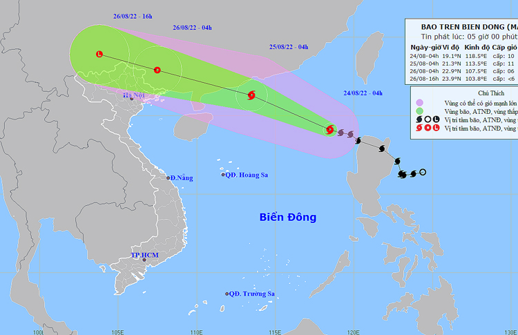 |
| The expected track of tropical storm Ma-on (Source: NCHMF) |
Thundery rain is expected to continue over the warning areas until Friday, August 26 . However, the chances of showers and thunder will gradually diminish from Saturday, August 27. Thunderstorms can produce tornadoes, lightning, hail and strong winds in the warning areas. Forecasters have also issued warnings of flash floods and landslides for mountainous areas in the affected parts, and localized flooding alerts are in place in low-lying and riverside areas.
In its latest bulletin, NCHMF said at 4:00am on Wednesday, August 24, the Tropical Storm Ma-on was already centred near latitude 19°1'N and longitude 118°5'E, about 630km southeast of Hong Kong, China. The maximum sustained winds reaching level 10 (89-102km per hour), and the gusts as high as level 13 will affect areas near the storm’s center. The radius of strong winds at level 6 and gustiness of level 8 was about 150km from the storm’s center.
Ma-on was tracking northwestward across the East Sea at 20-25km per hour on early Wednesday, August 24 after making landfall over Maconacon Town in Isabela Province, Philippines on early Tuesday, August 23 and transiting northern Luzon.
Forecast models indicate that the storm will continue its track west-northwest across the East Sea in next 24 hours, strengthening further into a typhoon by Thursday morning, August 25.
At 4:00am on Thursday, August 25, the storm’s center will be postioned near latitude 21°3'N and longitude 113°5'E, lie to the Northeast of the East Sea, about 190km Southwest of Hong Kong, China. The area near the center of the storm will experience strong winds at level 11 (103 - 117km per hour) and the gusts as high as level 14.
Over the next 24 hours, an advisory for strong winds, high waves, and tornadoes along with warning for level 3 natural disaster risk has been issued for all vessels operating in the potentially dangerous area which is set to be located near latitude 17°N and longitude 111°E.
Over the next 24 to 48 hours, the storm will continue moving west-northwestward at 25km per hour and then weaken into a tropical depression after making landfall over western Guangdong Province, China, just west of Macau later Thursday, August 25.
At 4:00am on Friday, August 26, Ma-on will be centred near latitude 22°9'N and longitude 107°5'E. The maximum sustained winds reaching levels 6 to 7 (39-61km per hour), and the gusts as high as level 8 will affect areas near the storm’s center.
Over the next 24 to 48 hours, the danger area in the East Sea Sea around the tropical storm which is located near latitude 19°N and longitude 108°'E- 116°5'E, could see strong winds at level 6 or higher, and the gusts as high as level 8 or higher. Warning for strong winds, big waves, and tornadoes along with along with alert for level 3 natural disaster risk has been issued for all vessels operating in the danger area.
Over the next 48 to 60 hours, the tropical depression will continue its track west- northwest at 20-25km per hour across southern Guangxi Province in China and then southern Yunnan Province in China. The depression will be then weakened to a remnant area of low pressure and dissipate over southwestern Yunnan Province on Saturday afternoon, August 27. The maximum sustainable winds at the center of the remnant low-pressure system will decrease below level 6 (below 39km per hour).
Due to the influence of tropical storm Ma-on, the Northeastern part of the East Sea will see thunderstorms and high winds at levels 6 to 7, and then increase to levels 8 to 9. The maximum sustained winds reaching levels at 10 to 11, and the gusts as high as level 14 will affect areas near the storm’s center with rough seas and waves as high as 6m to 8m.
Under these conditions, moderate to heavy rains with thunderstorms at most places with extremely heavy rainfall at isolated places from evening and night hours on Thursday into Saturday, August 27 are also likely over the Northern region and Thanh Hoa.
Reporting by Baotintuc – Translating by H.L