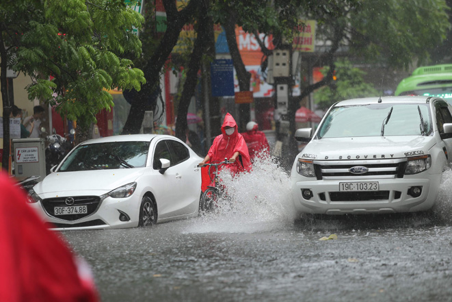
Shower and thunderstorm warning remains in place for many parts of the country
According to Viet Nam’s National Centre for Hydro-Meteorological Forecasting, moderate to heavy rainfall with thunderstorms are expected to occur in Northern Viet Nam and Nothern Central Coast during daytime and night hours on Sunday. National forecasters indicate heavy to extremely heavy rains of 30 mm to 70mm, and even in excess of 100mm, in a 24 hour period, at isolated places in these areas. However, rainfall activity is likely to reduce in these areas from Monday, August 22, the national weather service has indicated.
 |
| Showers with the possibility of thunderstorms will continue to affect Northern and Sourthen regions, Northern Central Coast and Central Highlands. |
Showers with thunderstorms at most places with heavy rainfall at isolated places during afternoon and evening hours are also likely over Central Highlands and the Southern region today under the influence of the southwest monsoon. Localized rainfall accumulations could reach 20mm to 40mm, and localized accumulations in excess of 60mm in a 24 hour period are possible on Sunday.
Thundery showers will stay in the forecast for Central Highlands and the Southern region over next few days.
Thunderstorms can produce tornadoes, lightning, hail and strong winds in the warning areas. Forecasters have also issued warnings of flash floods and landslides for mountainous areas in the affected parts, and localized flooding alerts are in place in low-lying and riverside areas.
Today, the national weather service issued a warning for showers and thunderstorms for the Gulf of Tonkin, the offshore areas stretching from Quang Tri to Quang Ngai, including Da Nang, Binh Thuan to Ca Mau, Ca Mau to Kien Giang and the Gulf of Thailand. However, reduction in rainfall activity is likely in these areas from Sunday night. Thunderstorms can produce tornadoes, and strong winds at levels 7 to 8 in the warning areas, meteorologists at the National Weather Service said.
Today expects the sky to remain mostly cloudy over the parts from Thanh Hoa to Thua Thien-Hue with a chance of scattered showers and thunderstorms at most places while heavy rainfall is expected at isolated places. Maximum temperatures in the Northern and Southern parts of the region are expected to hover around 28-31 degrees Celsius, and 31-34 degrees Celsius, respectively while minimum temperature will be in the range of 22-25 degrees Celsius over most parts of the region.
The national forecasters have warned that there will be showers with the possibility of thunderstorms at isolated localtions over the parts from Da Nang to Binh Thuan during late afternoon and night hours on Sunday. The southwest wind at levels 2 to 3 could reach the region. Temperatures in these areas can expect lows of 24 to 27 degrees Celsius and highs of 31 to 34 degrees Celsius, even above 34 degrees Celsius in some places.
Thunderstorms can produce tornadoes, lightning, hail and strong winds, national forecasters has warned.
Reporting by Baotintuc – Translating by H.L