Storm Ma-on with wind gusts level 14 causes high winds and big waves at sea
Viet Nam’s National Centre for Hydro-Meteorological Forecasting (NCHMF) predicts that heavy rainfall and thunderstorms are likely to lash over Northern Viet Nam and Thanh Hoa Thursday afternoon into Friday night, August 26 with extremely heavy rain likely in some places. National forecasters indicate extremely heavy rainfall of 100mm to 200mm, and even in excess of 250mm at isolated places in these areas.
As much as 50mm-100mm of rain could fall over Thanh Hoa, and even more than 150mm at isolated locations. The rainfall activity in the Northern region and Thanh Hoa is likely to reduce from Saturday, August 27.
Due the influence of the southwest monsoon, the best chance for showers and thunderstorms at most places during the daytime and night hours with heavy rainfall and thunder during the afternoon and evening hours at isolated places on Thursday will be in South Central Coast, Central Highlands and the Southern region. The total rainfall amount will be 10mm to 30mm in common in these areas while more than 50mm of rain could fall in some places.
Thundery rain is expected to continue over Central Highlands and the Southern region until Friday, August 26. However, the NCHMF said that there is likely to be a decrease in rainfall activity over these areas from Saturday, August 27.
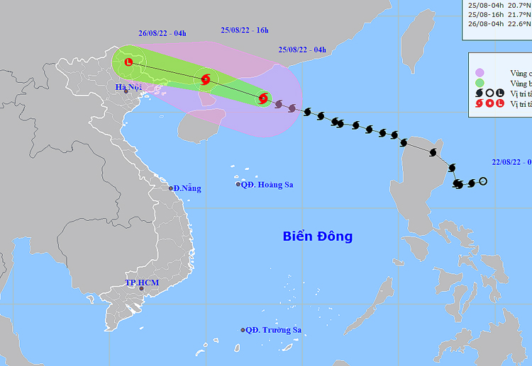 |
| The map shows the expected path of storm Ma-on. Photo: NCHMF |
In its latest bulletin, the National Weather Service said that at 4:00am on Thursday, August 25, storm Ma-on was already centred near latitude 20°7'N and longitude 113°E, lied to the northern part of the East Sea, about 290km east of Leizhou Peninsula, China. The maximum sustained winds reaching level 11 (103-117km per hour), and the gusts as high as level 14 will affect areas near the storm’s center. The radius of strong winds at level 6 and gustiness of level 8 was about 170km from the storm’s center.
Over the next 12 hours, the storm will move in a west-northwesterly direction at about 25km per hour.
At 4:00 pm on Thurday, the storm's center will be positioned near latitude 21°7'N and and longitude 110°E, right on the southern mainland of Guangdong Province, China, about 230km east of Mong Cai City, Quang Ninh Province. The area near the center of the storm will experience strong winds at levels 9 to 10 (75-102km per hour) and the gusts as high as level 12.
Forecast models indicate that the storm will continue its track west-northwest about 25km per hour over the next 12 to 24 hours, and then gradually weaken into a tropical depression after making landfall over western Guangdong Province, China. The depression will be then weakened to a remnant area of low pressure over the northern mountainous region. The maximum sustainable winds at the center of the remnant low-pressure system will decrease below level 6 (below 39km per hour).
Over the next 24 hours, an advisory for strong winds, high waves, and tornadoes along with warning for level 3 natural disaster risk has been issued for all vessels operating in the potentially dangerous area which is set to be located near latitude 18°5N and longitude 115°E.
Due to the influence of tropical storm Ma-on, the northeastern part of the East Sea will see thunderstorms and high winds at levels 8 to 9. The maximum sustained winds reaching level 11, and the gusts as high as level 14 will affect areas near the storm’s center with rough seas and waves as high as 6m to 8m.
Under these conditions, the northern part of the Gulf of Tonkin (including Bach Long Vy and Co To islands could witness gradually increasing strong winds at levels 6 to 7 from Thursday noon. The area near the center of the storm will experience strong winds at level 8, and the gusts as high as level 10, rough seas and waves as high as 2.5m-3.5m.
Strong wind warning has been issued for the coastal area of Quang Ninh Province and the parts from Hai Phong and Lang Son as these areas could see high winds at level 6 and the gusts as high as level 8 as well as gusty winds at levels 6 to 7, respectively, from Thursday afternoon into Friday morning.
The NCHMF has also issued heavy rain alert in the Northern region and Thanh Hoa from Thursday afternoon into Friday night. Heavy to very heavy rainfall with thunderstorms and gusty winds are predicted over the Northern region as it could receive between 100mm and 200mm of rain, with more than 150mm possible in some places. As much as 50mm-100mm of rain could fall over Thanh Hoa and even more than 150mm at isolated localtions.
The best chance for scattered showers and thunderstorms will be in most parts from Da Nang to Binh Thuan in the late Thursday afternoon while few places will experience very heavy rainfall. In addition, showers and thunderstorms are possible at isolated places during night hours. Temperatures in these areas can expect lows of 25 to 28 degrees Celsius and highs of 31 to 34 degrees Celsius.
Thunderstorms can produce tornadoes, lightning, hail and strong winds, national forecasters has warned.
Reporting by Baotintuc – Translating by H.L