Fast-moving storm Noru to impact Central Viet Nam with heavy rain from Sept 27
A tropical depression in the Pacific Ocean or the eastern part of the Philippines has intensified into a tropical storm and it was named Noru, according to Viet Nam’s National Center for Hydro-meteorological Forecasting (NCHMF).
 |
| The expected track of Noru (Source: The National Centre for Hydro-Meteorological Forecasting) |
NCHMF has issued a forecast saying that Noru is moving quickly over the eastern part of the Philippines. A high wind watch has been issued for the offshore areas stretching from Quang Tri to Quang Ngai, including Da Nang, from early morning on September 27. The area near the storm’s center will experience high winds at levels 10 to 11, and gustiness of level 14. The storm is expected to grow even stronger as it is moving over the East Sea.
The storm is expected to bring heavy rain to Central Viet Nam, including Da Nang, from September 27 to 29. People in the waring area should be aware of the danger of heavy to very heavy rain and accumulated rain. This can cause flash floods, especially the hillsides near waterways and marshy areas.
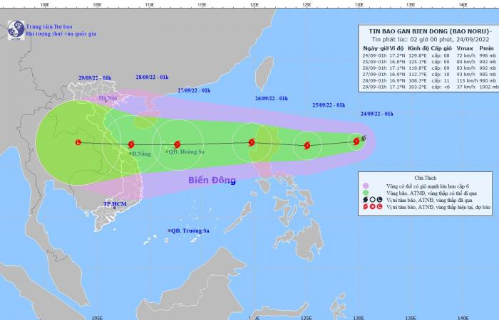
Forecast models indicate at 1:00am on Saturday, September 24, the storm’s center was already located near latitude 17°2'N and longitude 129°8'E, about 810km northwest of Luzon Island, Philippines, with the maximum sustained winds reaching levels 8 to 9, and gustiness of level 11.
Over the next 24 hours, Noru will likely continue to strengthen as it tracks west- southwest at about 20 kilometres per hour. At 1:00am on Sunday, September 25, the storm’s center will be positioned near latitude 16°8'N and longitude 125°1'E, about 300km east of Luzon Island, Philippines, packing maximum sustained winds of levels 9 to 10, and and the gusts as high as level 13.
Noru will continue to move toward the west at about 20 -25 kilometres per hour in the next 24 hours, and then enter the East Sea. At 1:00am on Monday, September 26, the storm will be centred near latitude 17°1'N and longitude 119°8'E, lie to the west coast of Luzon Island, Philippines, about 790km east of the Hoang Sa Archipelago, with the maximum sustained winds reaching levels 9 to 10, and gustiness of level 13.
The storm will likely gain strength as it continues towards the west at about 30km kilometres per hour. At 1:00 am on Tuesday, September 27, the storm’s center will be positioned near latitude 16°9'N and longitude 112°7'E, lie to North of the Hoang Sa Archipelago, packing maximum sustained winds of levels 10 to 11, and the gusts as high as level 14.
From Sunday noon and afternoon, September 25, due to the influence of storm Noru, the Northern part and the middle of the East Sea will see gradually increasing strong winds at levels 6 to 7, while the area near the storm’s center will experience high winds at levels 8 to 9, and gustiness of level 11 with rough seas and waves as high as 4m to 6m.
The storm is expected to grow stronger as it tracks the west at 25 kilometres per hour. The national weather service forecasts the storm to weaken after making landfall as a tropical storm over the mainland.
 |
| In recent times, Da Nang has taken urgent action to thin out the tree lines on urban streets city-wide in a bid to cope up with this year’s upcoming rainy and storming season. Photo: HOANG HIEP |
The Da Nang Steering Committee for Disaster Response and Search and Rescue is urging authorities at local level and relevant units to take mitigation measures in response to storm Noru.
The Da Nang Border Guard Command is asked to work with Da Nang Coastal Information Station to keep a close watch on storm developmen in the East Sea in order to keep owners of vessels operating at sea timely informed about severe weather conditions to help them take the initiative to avoid dangerous areas or seek safe shelters during the bad weather.
Special attention must be given to making the resources available in order to organize timely rescue of any person in distress at sea and provide timely support for those who need it during severe weather.
Reporting by HOANG HIEP – Translating by H.L