Tropical depression moves fast, causing heavy rains from Quang Tri to Quang Ngai, including Da Nang
A low-pressure area in the southeastern part of the Hoang Sa Archipelago has strengthened into a tropical depression, according to Viet Nam’s National Center for Hydro-meteorological Forecasting (NCHMF).
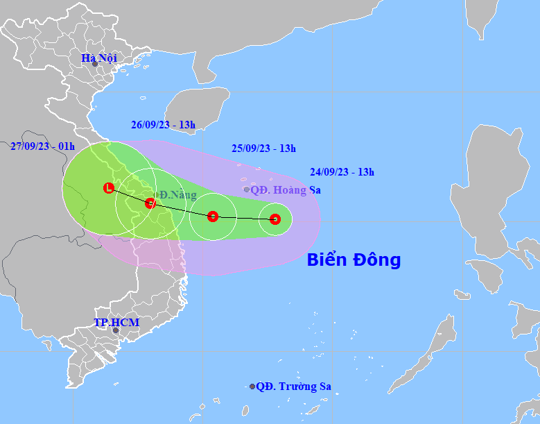 |
| The forecast track of the newly-formed tropical depression over the East Sea. (Source: NCHMF) |
In its latest bulletin, the National Weather Service said that at 1:00 pm on Sunday, the centre of the depression was positioned at latitude 15°1'N and longitude 112°8'E, about 200km southeast of Hoang Sa Archipelago, with the maximum sustained winds reaching level 6, and the gusts as high as level 8.
Over the next 24 hours, the tropical depression will move westward at a speed of 10-15kmph.
At 1:00 pm on September 25, the center of the tropical depression was at latitude 15°2'N and longitude 110°4'E, about 170km east of Quang Ngai Province and 230km east of Da Nang with the strongest winds reaching level 6-7 and gusts at level 9.
The danger zone at sea in the next 24 hours is at latitude 13°5'N-16°5'N and longitude 109°E-114°5'E.
After that, the tropical depression will change direction to move west-northwest at a speed of 10-15km/h.
Due to the influence of tropical depression, the southwest part of North of the East Sea, including the Hoang Sa Archipelago, and the northwest part of the Middle of the East Sea, will see heavy showers, strong thunderstorms and maximum sustained winds at level 6, gustiness of level 7, and experience rough seas.
Starting from the afternoon of September 25, coastal areas from Quang Tri to Quang Ngai, including Da Nang, will experience strong winds at levels 6-7 and rough seas.
Between September 25 and 27, Da Nang and elsewhere in the central, central highlands and southern regions, are forecast to witness moderate to heavy rain, and thunderstorms.
Some places in the North Central and Mid-Central regions are being warned to brace for heavy rain, with rainfalls of 100-350mm, whilst other places in South Central, Central Highlands and Southern regions will see average rainfalls of 100-200mm.
The Da Nang Steering Committee for Disaster Response and Search and Rescue is urging authorities at local level and relevant units to take mitigation measures in response to severe weather conditions at sea.
The Da Nang Steering Committee for Disaster Response and Search and Rescue is also asking the Da Nang Border Guard Command to work with Da Nang Coastal Information Station to keep a close watch on disturbance development in order to keep owners of vessels operating at sea timely informed about severe weather conditions in order to help them take the initiative to avoid dangerous areas or seek safe shelters during the bad weather.
The Da Nang Border Guard Command will keep a close watch on offshore and inshore vessels and make the resources available in order to organize timely rescue of any person in distress at sea and provide timely support for those who need it during severe weather.
Reporting by HOANG HIEP - Translating by M.DUNG