Da Nang residents on alert for heavy downpours and strong winds as tropical depression may strengthen into storm
A tropical depression, which could intensify into a storm in the next 24 hours, brings heavy rainfall of 100-300mm and strong winds to the central region from Wednesday to Friday, according to the National Centre for Hydro-meteorological Forecasting.
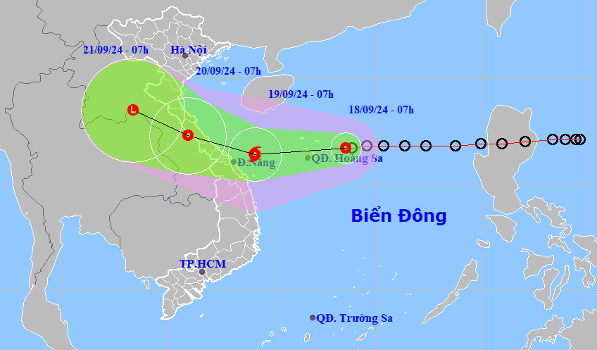 |
| A map detailing the projected path of a tropical depression, which could intensify to become the fourth storm to hit the East Sea in 2024. Photo courtesy of the National Center for Hydrometeorological Forecasting |
At 7:00 am on Wednesday, the tropical depression was spotted about 210km east southeast of Quang Tri Province and about 120km east of Da Nang, packing maximum sustained winds at levels 8-10.
The dangerous area in the East Sea in the next 24 hours is at latitude 15°00'N - 19°00'N and longitude 109°E - 115°E.
The system is expected to march west-southwest at around 20km per hour in the following 24 hours and pick up strength to become the fourth storm to hit the East Viet Nam Sea this year.
Due to the influence of the tropical depression and further storm, the northern part of East Sea, including the Hoang Sa Archipelago, has strong winds of level 8 (62-74 km/h), with gusts up to level 10 (89-102 km/h) and waves as high as 3-5 metres, creating rough seas.
On land, from September 18 to 20, Da Nang may experience heavy to very heavy rainfall of 100-300mm, with several places seeing more than 400mm.
Due to the influence of the tropical depression which will later strengthen into a storm, Da Nang needs to stay alert to thunderstorms, tornadoes, hail and strong gusts of wind.
The national weather agency noted that fishing boats and vessels operating in the Da Nang sea could be impacted by thunderstorms, whirlwinds, powerful winds, and high sea waves.
Reporting by HOANG HIEP - Translating by M.DUNG