Tropical depression brings moderate to heavy rain to central Viet Nam
Due to the influence of storm No. 7 weakening into a tropical depression and a low pressure area over the maritime area from Thua Thien Hue to Binh Dinh provinces, Da Nang braced for moderate to heavy downpours, with excessive rainfall and thunderstorms recorded in several areas from the evening of November 11 to the morning of November 12.
 |
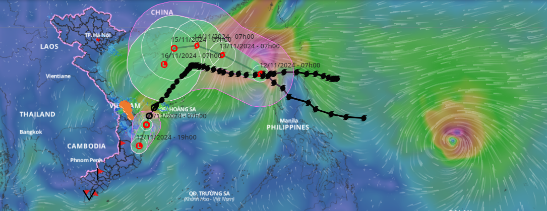
| A map showing the direction and location of a tropical depression weakening from typhoon Yinxing, the seventh storm to affect the maritime area; typhoon No.8 called Toraji; and a new typhoon forming off the Philippines. Source: Vietnam Natural Disaster Monitoring System |
At 7:00 am on Tuesday, the tropical depression was centered in the waters from Quang Nam to Binh Dinh provinces, packing sustained winds of level 6 and gusts of level 8.
The depression moved southwest at a speed of 15-20 kph and then weakened into a low pressure area. At 7:00 pm on November 12, the center of the low pressure area was at about 13 degrees north latitude, 109.1 degrees east longitude in the coastal areas of the provinces from Quang Ngai to Phu Yen with the strongest winds of below level 6.
Influenced by the tropical depression, the sea areas from Thua Thien Hue to Phu Yen provinces, including Ly Son Island District, had rough seas with waves of two to three meters in height. Fishing boats operating in dangerous areas are likely to be affected by whirlwinds, strong winds, and large waves.
The Mid-Central Region Centre for Hydro-meteorological Forecasting has warned of moderate to heavy rain in the provinces and cities from Thua Thien Hue to Quang Ngai from now until Wednesday morning. Rainfall of 50-100mm is possible in Da Nang and Thua Thien Hue Province, and 50-150mm in Quang Nam and Quang Ngai provinces.
In addition, flash floods and landslides may occur in mountainous areas, while flooding may hit low-lying and urban areas in the provinces and cities from Thua Thien Hue to Quang Ngai.
Meanwhile, Quang Binh and Quang Tri provinces could see scattered, moderate and heavy rain with common rainfall of 10-30mm, with over 50mm in some parts.
The National Centre for Hydro-Meteorological Forecasting reported that as of 7:00 am of November 12, typhoon Toraji, the eighth storm to hit the East Vietnam Sea this year, was centered at 18.5°N latitude and 118.7°E longitude, with winds blowing at level 10 (89-102 km per hour) and gusts reaching level 12.
The storm is anticipated to maintain its northwestward trajectory at a speed of 10-15 km per hour. Meteorologists expect Toraji to gradually weaken starting November 15, diminishing to a tropical depression as it continues towards the northwestern East Sea.
Reporting by HOANG HIEP - Translating by M.DUNG


