Super Typhoon Meranti targets Taiwan, mainland China
Taiwan and China are bracing for the approach of Super Typhoon Meranti, which is forecast to bring torrential rains and damaging winds on Wednesday.
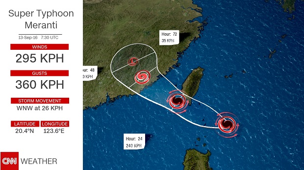 |
In the last 24 hours, the typhoon transformed from a Category 1 storm to a top-scale Category 5 hurricane.
Currently, it is sustaining winds of 183 miles per hour (295 kph) with gusts up to 223 mph (360 kph). The storm is forecast to just miss making direct landfall over southern Taiwan and track through the Luzon Straights towards China.
Even though Meranti, which likely will still be a super typhoon at landfall (meaning the winds are in excess of 150 mph/240 kph) on the southern tip, the entire island will feel the storm's wrath.
The tropical storm-force wind field from Meranti stretches more than 350 miles (560 km) from one end to the other; Taiwan is only about 230 miles long.
Dangerous winds, however, are only one of the potentially devastating impacts Meranti will unleash on Taiwan and then mainland China. Torrential rainfall, which frequently accumulates to over 3 feet (1 meter) over the mountainous terrain of central Taiwan during typhoons, can produce deadly flash floods and devastating mudslides.
Despite weakening to a tropical storm as it hit mainland China, Nepartak and the associated heavy rainfall of up to 10 inches (254 mm) killed more than 80 people. Meranti is expected to be much stronger than Nepartak when it hits mainland China, with winds around 115 mph (185 kph), which would make it equivalent to a major Category 3 hurricane in the Atlantic.
A combination of very warm western Pacific ocean waters and weak upper level winds have allowed Meranti (pronounced me-run-ti) to undergo what meteorologists call "rapid intensification." It went from 85 mph (140 kph) on Sunday to a sustained 180 mph (285 kph) on Monday afternoon.
Rapid intensification presents great challenges to forecasters and disaster management officials, as it can quickly up the ante when it comes to expected impacts from tropical cyclones.
If the forecast holds, and Super Typhoon Meranti makes landfall with winds of 155 mph (250 kph), it would be the strongest typhoon to make landfall in Taiwan since Super Typhoon Bilis in 2000.
(Source: CNN)