Tropical depression Son Tinh continues to bring rain to city into Saturday
The National Centre for Hydro-Meteorological Forecasting (NCHMF) says Typhoon Son Tinh, the 3rd of its kind this year formed in the East Sea, weakened into a tropical depression early this morning after having made a direct landfall in the localities of Thanh Hoa and Nghe An last night.
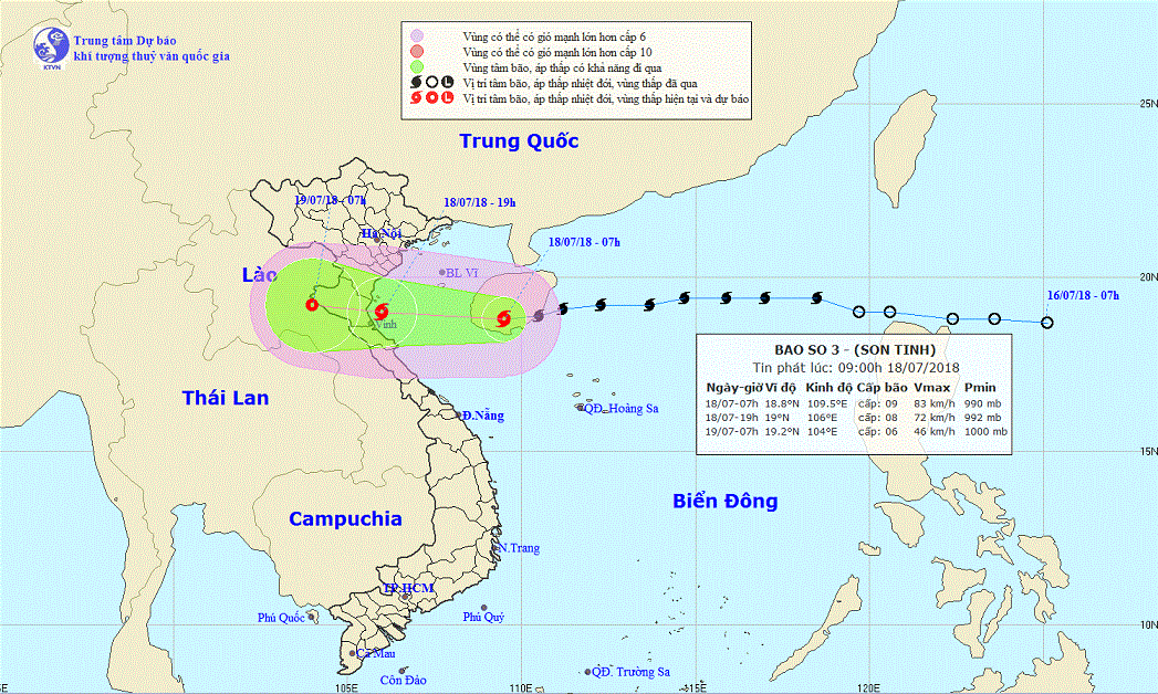 |
| A map detailing the route of the tropical depression from 18 to 19 July 2018. Photo: NCHMF |
At around 4.00am today, the depression’s centre was positioned at latitude 18°9’N and longitude 104°9’E, on the mainland of the north central region, packing wind speeds of 40 - 50 kph (level 6) near its centre, and gusts of level 8.
Afterwards, the depression moved in the western direction at a velocity of between 20 and 25 km an hour, and downgrade to a low pressure system lying in a border area between Viet Nam and Laos.
This afternoon, the depression was positioned at latitude 19°5’N and longitude 102°0’E, on the mainland of the central Laotian region, with wind speeds reducing slightly to under 40 kph.
Under the influence of the tropical depression, moderate to heavy rain are expected to continue in the northern and north-central regions until Saturday, especially torrential rain in localities from Thanh Hoa to Ha Tinh.
According to the national forecasters, Da Nang is expected to continue experiencing scattered showers and thunderstorms in some parts into Saturday.
However, from Sunday onwards, the city is likely to see sunny and cloudy weather in the daytime with the temperatures hovering at between 27 to 33 degrees Celsius, whilst the lowest humidity is reported as around 87%.