Storm Noul weakens into tropical depression, continues decreasing in intensity
Storm Noul weakened into a tropical depression an hour after making landfall in the central provinces from Quang Binh and Thua Thien-Hue on Friday morning, the National Center for Hydro-Meteorological Forecasting said.
 |
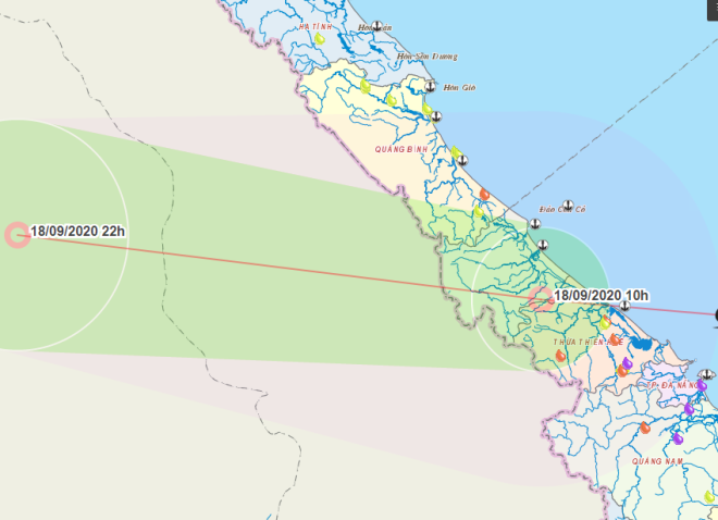
| The expected track of the tropical depression (Source: The Central Steering Committee for Natural Disaster Prevention and Control) |
As of 10 am today, the tropical depression’s centre was positioned at latitude 16°6’N and longitude 107°2’E, right on the coast of Quang Tri and neighbouring Thua Thien- Hue, with strong winds levels 6-7, with a gust of level 8 near its centre.
In the coming hours, the tropical depression is predicted to move westwards at a velocity of 20 kph and continue decreasing in intensity to weaken into a low pressure zone over central Laos at 7.00pm today.
Due to the strong influence of the tropical depression, the Gulf of Tonkin and the coast off central provinces from Quang Binh to Quang Ngai, the Con Co and Ly Son islands, are bracing for strong winds level 6, a gust of level 8, high and rough seas.
In Da Nang alone, the cloudy and wet weather is lingering into tomorrow with scattered showers expected to pour down onto some of the city’s parts.
Given the tropical depression-triggered rain, the city now appears to be cooler with its thermometers dipping between 24 to 29 degrees Celsius. The humidity level is reported as low as 74%.
However, stretches of cloudy and dry days would come back to the city from 20 September onwards.
The East Sea could see 11-13 storms and tropical depressions this year, half of them affecting the country, national meteorologists have warned.
By HOANH HIEP - Translated by A.T