Storm Saudel could weaken into depression before hitting Vietnamese coastline from Ha Tinh to Quang Binh
Vietnamese and international weather forecasters similarly say storm Saudel will lose its intensity, and is then likely to weaken into a depression before making landfall in Central Viet Nam coastline from Ha Tinh to Quang Tri that are suffering from their worst flooding in two decades. However, the alert against the storm’s threat to coastal aquaculture and fishing activities at sea with its string wind gusts remained in place.
 |
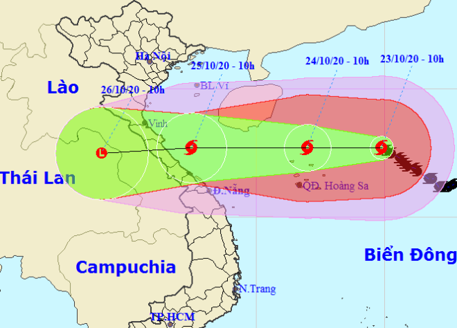
| Storm Saudel tracking map (Source: The National Hydrology Meteorology Forecast Centre) |
At 7am on Friday, the center of storm Saudel was about 320 km east of Viet Nam’s Hoang Sa (Paracel) Archipelago in the East Sea, packing the sustained strong winds of up to 150 kph, the National Centre for Hydro-Meteorological Forecasting said.
In the next 24 hours, Saudel will continue moving westward at 15 kph and hit north of the Hoang Sa Islands at around 7am Saturday, 24 October.
After that, at 11am on Sunday, 25 October, the storm’s eye should be located at near latitude 17°7’N and longitude 107°5’E, right on the coast off Ha Tinh - Quang Tri provinces, packing maximum winds falling to only level 8, and a gale of 10.
Vietnamese forecasters say Saudel could weaken into a tropical depression before hitting flooded Ha Tinh - Quang Tri provinces on Sunday night, and become post-tropical remnant low.
In particular, meteorologists’ notifications show Saudel would not bring as much rain as the previous two storms but will produce whirlwinds and and thunderstorms in central coastal regional localities.
They also warned that the remnants of Saudel combined with a cold front moving from the northeast would be very dangerous to vessels and fish farms near the coast.
Meanwhile, the national weather service also reported a fresh disturbed zone to the far east of the Philippines that boasts the potential to develop into a tropical depression and creep into the East Sea.
Till date, owners of Da Nang’s offshore vessels are urged to to keep up with the latest Saudel watches and warnings with the national weather service so that they can steer clear of the dangerous zones at sea.
Under the impact of Saudel, the waters off Da Nang are experiencing scattered showers accompanied by thunderstorms, strong gale of level 7, sea waves from 2 to 3.5 m high, and very rough seas.
This weekend and subsequent days, Da Nang’s mainland is forecast to wake up to a cloudy and soaking weather with moderate to heavy showers. Its thermometers should gradually dip between 21 to 28 degrees Celsius in the daytime, and turn a bit chilly in the night time.
 |
| Municipal People's Committee Vice Chairman Ho Ky Minh (centre) chaired an emergency response meeting on Friday morning |
Municipal People's Committee Vice Chairman Ho Ky Minh has directed relevant agencies to take proactive measures to respond to the upcoming storm.
Mr Minh also urged the authorities of districts across Da Nang to immediately evacuate people living in low-lying areas, and landslide and flash flood-prone areas, especially those living along local rivers.
By HOANG HIEP – Translated by A.T