Storm Atsani could downgrade to tropical depression and dissipate over East Sea
Viet Nam's National Center for Hydro-meteorology Forecasting (NCHFM) has spotted recently-formed severe tropical storm Atsani which entered the East Sea on Saturday morning.
 |
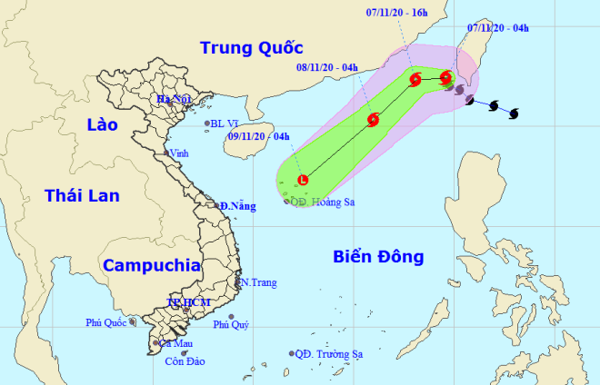
| Storm Atsani tracking map (Photo: NCHFM) |
Atsani, the 19th tropical cyclone to sweep the Philippines this year, crossed Batanes, an island province in the northernmost tip of this natural disasters -weary South East Asian country on Friday.
At 4:00pm today, Atsani is projected to be centred at about 220km southwest of Taiwan, the self-governing island China considers a province, packing with the strongest sustained winds of levels 8-9, with a gale of above level 11.
In the next 12-24 hours, the storm is expected move southwestward at 20-25kph, with its intensity slowing.
At 4.00am tomorrow, on 8 November, the centre of the storm is forecast to be located at about 580km northeast of the Hoang Sa (Paracel) Archipelago with the maximum wind intensity falling a bit to level 8, and a gust of level 10.
In the subsequent hours, Atsani is predicted to move southwestward, and gradually weakened into a post-tropical low remnant and then started to dissipate, the national weather forecast bureau said in its latest bulletin.
Atsani hit the Philippines as the country reels from the trail of destruction brought by Super typhoon Goni last Sunday that left at least 20 dead. Typhoons and tropical storms regularly batter the Philippines from June through December, claiming hundreds of lives and cause billions of dollars in damages.
The storm is now bringing up looming menaces at sea, with vessels operating in the affected zones bearing high risks from gusts, NCHFM warned.
 |
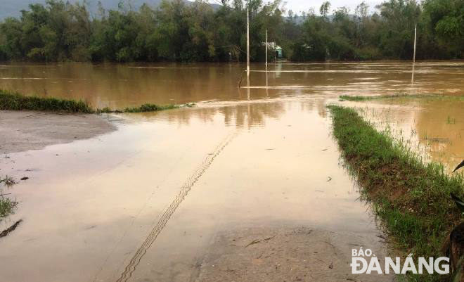
| Picture taken at a flooded road in Dai Nghia Commune, Dai Loc District, Quang Nam Province, downstream of the Vu Gia river on Saturday morning |
Meanwhile, in Central Viet Nam, floodwater discharged from hydropower dams on the upstream of Vu Gia and Thu Bon rivers was blamed for flooding many areas in Da Nang’s Hoa Vang District and neighouring Quang Nam Province ’s suburb Dai Loc District on Saturday morning, according to Da Nang Steering Committee for Natural Disaster Prevention and Search and Rescue data.
The unexpected incident made the affected residents’ lives turn upside down.
Of special note, landslide warnings have been issued for some mountainous parts of the central provinces of Quang Nam and Quang Ngai, especially in the mountainous districts of Dong Giang, Nam Giang, Tay Giang, Phuoc Son, Que Son, Tien Phuoc, Nam Tra My, Bac Tra My, Hiep Duc , Nong Son, and the districts of Ba To, Minh Long, Tra Bong, Son Ha and Son Tay in Quang Ngai Province.
Meanwhile, flooding could occur in some certain low-lying and riverside areas in Quang Nam and Quang Ngai.
By HOANG HIEP – Translated by A.T