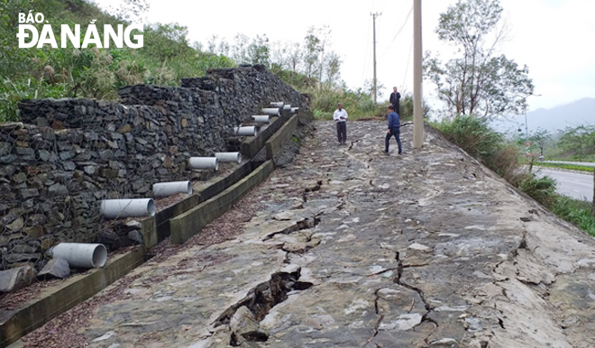
Landslides on Hoang Van Thai route leading to Ba Na - Suoi Mo tourist site need properly resolving
The extended Hoang Van Thai route linking the Da Nang centre to the Ba Na - Suoi Mo tourist site, passing through Hoa Khanh Nam Ward in Lien Chieu District and the communes of Hoa Son, Hoa Ninh, Hoa Nhon and Hoa Phu in Hoa Vang District, is dubbed as “the arterial route” to the west of Da Nang. However, over recent times, there have been many landslides along this long route, posing potential danger to vehicles and road users.
 |
| Some anti-erosion taluses along the extended Hoang Van Thai route suffer serous landslides, which poses potential danger to road users. (Photo taken in May 2021 by THANH LAN) |
Built solidly, synchronously and modernly, the 10.46km-long, 6-lane Hoang Van Thai route, stretching through many mountainous terrains, meeting the standard technical parameters, is considered one of the most beautiful tree-lined roads in Viet Nam.
After 18 months of construction, the extended Hoang Van Thai street was officially opened to traffic on 25 April 2015 marking the 40th anniversary of the liberation of the South and national reunification (30 April 1975 - 30 April 2015).
The road has been recognised an a grade II urban street as meeting technical standards of 21m-wide road surface, 3m-wide separating strips, 10m-wide roadside and a speed limit of 60km/h. The road is a tree lined avenue with no houses being built along its both sides, and it is the first of its kind in Viet Nam.
In addition, highly impressive floral decorations and miniatures are created on the road’s pavements, contributing to enhancing the urban beauty. Since it was opened to the traffic, the extended road helps to narrow the distance between the city centre and Ba Na Hills tourist area from 30km to about 20km and shorten the travel time from 35 minutes to about 20 minutes.
Putting the route into use creates a driving force to promote local tourism development and the
process of rural urbanisation, and beef up the socio-economic developments of the Hoa Vang and Lien Chieu districts.
However, the route witnessed some landslide points occur following the rage of storms, which caused potential danger to road users.
Previously, a few landslides happened at a traffic intersection near the DT 602 road, at the foot of the An Son Bridge. In particular, a volume of soil and stones spilled out onto a section of the extended Hoang Van Thai street running through Dai La Pass.
Pham Van Thanh residing in Son Tra District, a 43-year-old driver of a tourist coach, raised his deep concern over the landslide-prone areas along this route. If not upgraded properly before the coming rainy season, the road will be blocked by heavy downpours-triggered serious landslides, said Thanh.
On May 11, 2021, the municipal People's Committee issued an official dispatch on handling landslides on anti-erosion taluses along the section running through Dai La Pass.
Functional local bodies have placed warning signs on these landsides-ravaged sections of the whole route in order to ensure the ultimate safety of travellers, and avoid any unexpected incidents.
It is known that, in line with the direction of the municipal People's Committee, the Department of Transport has focused on carrying out the appraisal over the economic and technical reports on the upcoming reinforcement of the damaged sections of the extended Hoang Van Thai route.
For the time being, the city’s Traffic Infrastructure Management Centre and the Da Nang Bridge and Road JSC have completed all necessary preparations for the upgrade which is staled to start in late June or early July at a cost of VND 6.1 billion funded by the municipal budget.
Reporting by THANH LAN – Translating by A.T