Tropical Depression expected to strengthen into a storm, bringing rain and thunderstorms to Da Nang in next 3 days
Viet Nam’s National Centre for Hydro-Meteorological Forecasting is watching a newly-formed tropical depression which is getting stronger as it moves over the East Sea. The system is expected to intensify and strengthen into a tropical storm status, according to national forecasters.
Thunderstorm warning has been issued for Da Nang in the late afternoon and the evening from Monday into Friday. Warning covers large parts of the city so many places could see thundery showers, and some parts will witness moderate to heavy rainfall.
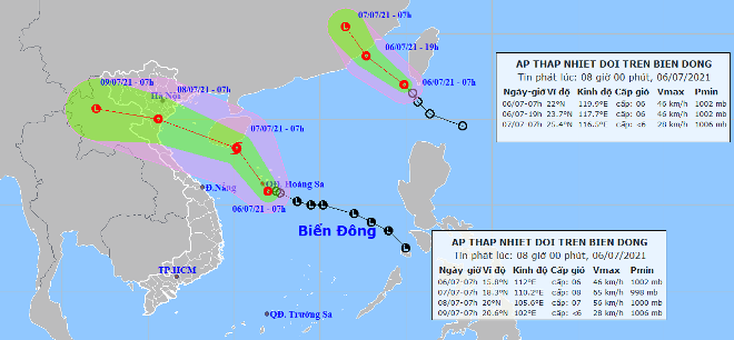 |
| The expected track of the tropical depression which is likely to strengthen into a storm (Source: The National Centre for Hydro-Meteorological Forecasting) |
The Mid-Central Region Centre for Hydro-meteorological Forecasting said on Monday morning (July 6), the depression’s centre was located at latitude15°8'N and longitude 112°E with the maximum sustained winds reaching level 6, and the gusts as high as level 8.
Over the next 24 hours, the system will move northwestward in the East Sea at 10-15kmph, and it will continue to gain strength and is likely to develop into a tropical storm.
At 7:00 am tomorrow (July 7), the soon-to-be-formed storm’s centre is predicted to be right on waters off the coast of south Hainan Island (China) with the maximum sustained winds reaching level 8, and the gusts as high as level 10. The storm will then change its direction and move toward the west-northwest at about 20kmph, and gradually weaken into a tropical depression as it moves further inland in China.
The western part of the Northern East Sea (including the waters of the Hoang Sa Archipelago) will see strong winds at level 6-7. The maximum sustained winds reaching level 8, and the gusts as high as level 10 will affect areas near the storm’s center with rough seas and waves as high as 2.5m to 4.5m.
The offshore area stretching from Binh Thuan to Ca Mau and the area between the East Sea and the South of the East Sea will see gradually increasing the southwest wind at level 5-6, and the gusts reaching level 7-8, and experience rough seas with waves as high as 2-3m.
In addition, showers and thunderstorms, strong gusty winds and hail will be possible in the East Sea (including the waters of the Truong Sa and Hoang Sa Islands), the offshore area stretching from Quang Tri to Ca Mau, from Ca Mau to Kien Giang, and the Gulf of Thailand.
Monday into Friday, under the influence of the new tropical depression combined with the developing southern low pressure trough, localities from Quang Binh and Quang Ngai will see showers and scattered thunderstorms in many places with some parts witnessing isolated moderate to heavy rainfall. There are weather warnings for strong gusty winds and hail for these areas.
Reporting by HOANG HIEP – Translating by H.L