Tropical depression to move into Gulf of Tonkin this afternoon, bringing isolated heavy rains to Da Nang
The tropical depression with the maximum sustained winds reaching level 8, and the gusts as high as level 8, is projected to move toward the west-northwest at about 25-30kmph into the Gulf of Tonkin on Wednesday afternoon (July 7) and continues to gain strength, according to Viet Nam’s National Centre for Hydro-Meteorological Forecasting.
The national forecasters have predicted isolated heavy rains at some places over Da Nang from Wednesday into Friday (July 9).
 |
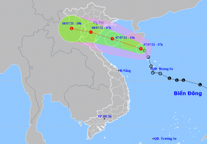
| The expected track of the tropical depression (Source: The National Centre for Hydro-Meteorological Forecasting) |
At 7:00am today (July 7), the depression’s centre was located southeast of Hainan Island (China) with the maximum sustained winds reaching level 6, and the gusts as high as level 8. The system is moving toward the west-northwest at 25-30kmph, and it can potentially become stronger and is expected to enter the Gulf of Tonkin this afternoon.
At 7:00 pm today (July 70), the depression is predicted to be postioned near latitude 19°5'N and longitude 107°5'E near the south of Bach Long Vi Island with the maximum sustained winds reaching level 6-7, and the gusts as high as level 9. The system will continue to move toward the west-northwest at about 20kmph and could directly affect the Northern Delta and North Central Coast.
At 7:00 am tomorrow (July 8), the system will be positioned near latitude 20°2 'N and longitude 105°2'E, right on the south of the Northern Delta and North Central Coast with the maximum sustained winds reaching level 6, and the gusts as high as level 7.
The danger area around the tropical depression which is located at latitude 17°5'N - 20°5'N and longitude 111°5'W could see strong winds at level 6 or higher, and the gusts as high as level 8 or higher. Warning for strong winds and big waves has been issued for all vessels operating in the danger area.
The western part of the Northern East Sea (including the waters of the Hoang Sa Archipelago) and the Gulf of Tonkin (including Bach Long Vi Island) will see strong winds at level 6-7, and the gusts as high as level 9.
The offshore area stretching from Quang Ninh to Ha Tinh will witness gradually increasing winds at level 6, and the gusts reaching level 8, and experience rough seas with waves as high as 2-3m.
The offshore area stretching from Binh Thuan to Ca Mau, the area between the East Sea and the South of the East Sea will see gradually increasing the southwest wind at level 5-6, and the gusts reaching level 7-8, and experience rough seas with waves as high as 2-3m.
There are weather warnings for the gusts reaching level 6-7 in the late afternoon and night on July 7 for the localities from Quang Ninh to Nghe An. Heavy to very heavy rainfall is likely to occur over Northern Viet Nam and North Central Coast from Wednesday through Thursday with popular precipitation about 100-250mm, and more than 300mm in some places. The hardest-hit areas will be the Northern Delta, Hoa Binh, Son La, Phu Tho, Yen Bai, Lao Cai, Thanh Hoa, and Nghe An.
The Mid-Central Region Centre for Hydro-meteorological Forecasting has issued warnings for showers and thunderstorms in many places over Da Nang, with some parts witnessing isolated moderate and heavy rainfall from Monday into Friday. In addition, there is a chance of thunderstorms in the late afternoon and early evening hours and sometimes tornadoes, lightning, and strong winds can develop.
The regional forecasters has also issued other watches for flash floods and landslides in mountainous areas and low-lying areas.
Reporting by HOANG HIEP – translating by H.L