Tropical depression moves slowly northwestward, dumps more rain in Da Nang
Due to the influence of the slowdown of the newly-developed tropical depression that lies in the west of Hoang Sa (Paracel) Islands in combination with the Intertropical convergence zone and easterly wave disturbances, the parts from Quang Binh to Quang Ngai, including Da Nang, will brace for further heavy rainfall from Thursday into Friday. The Da Nang government is urging authorities at local level and relevant units to continue to take steps to cope with heavy rains brought by the tropical depression.
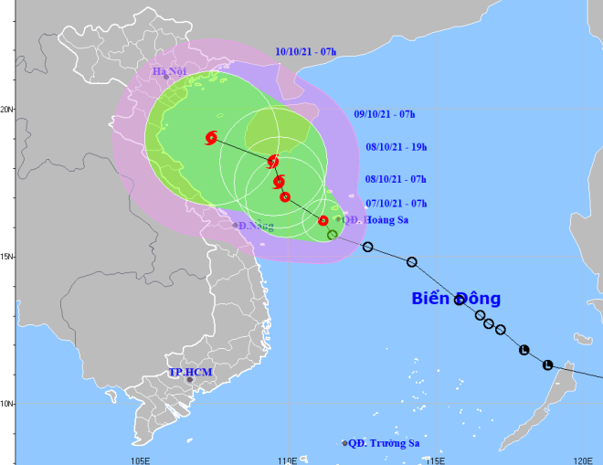 |
| The expected track of the newly-developed tropical depression storm with the potential to become a storm (Source: Viet Nam’s National Centre for Hydro-Meteorological Forecasting) |
In its latest bulletin, Viet Nam’s National Centre for Hydro-Meteorological Forecasting said at 7:00 am on October 7, the newly-developed storm's center was positioned at latitude 16°2'N and longitude 111°2'E, right on the waters off the western coast of the Hoang Sa (Paracel) Islands, packing maximum sustained winds at level 6 and gustiness of up to level 8.
The radius of strong winds at level 6 and the gusts as high as level 8 is about 80km from the tropical depression’s centre.
The depression will continue to move toward the northwest with velocity at 5-10km per hour over the next 24 hours, and it is expected to grow even stronger.
At 7:00 am on October 8, the depression will be positioned about 130km north of Hainan Island (China), with the maximum sustained winds reaching level 7, and the gusts as high as level 9.
The tropical depression will slowly move north-northwest at only 5km per hour, and it will continue to strengthen and is expected to build into a tropical storm.
Due to the influence of the tropical depression with the potential to become a storm, the south of the Gulf of Tonkin, the offshore areas stretching from Quang Binh to Quang Ngai (including Con Co, Ly Son and Cham islands) are expected to experience showers and severe thunderstorms, and these areas will see gradually increasing wind at level 6-7, and the gusts reaching level 8-10, and experience rough seas with waves as high as 2-4m. A tornado and strong wind watch has been issued for these areas by the national forecasters.
The south of the Gulf of Tonkin, the offshore areas stretching from Quang Tri to Ca Mau, Ca Mau to Kien Giang, the Gulf of Thailand, and the East Sea (including the waters of the Hoang Sa and Truong Sa islands) are expected to experience showers and severe thunderstorms with possible strong damaging winds and tornadoes.
From Thursday into Friday, the parts from from Quang Binh to Quang Ngai, including Da Nang, will brace for heavy to very heavy rain with a common rainfall of 150-300mm, and even more than 400mm in some places. Ha Tinh, Binh Dinh and the North of Central Highlands will see a common rainfall of 70-100mm, and even more than 100mm could fall in some places.
Widespread heavy rainfall is expected across the Northern Central Coastal Region and the Northern Delta from October 9-12.
Mountainous areas could face flash flood warnings and potential landslides, and flooding alerts have been issued for low-lying and riverside areas.
Reporting by HOANG HIEP – Translating by H.L