Typhoon Noru set to make landfall in Central Viet Nam on Sept. 28
Residents in Central Viet Nam, especially in Da Nang, are being urged to prepare for Storm Noru. The storm is expected to affect on September 28, bringing heavy rains and strong winds.
 |
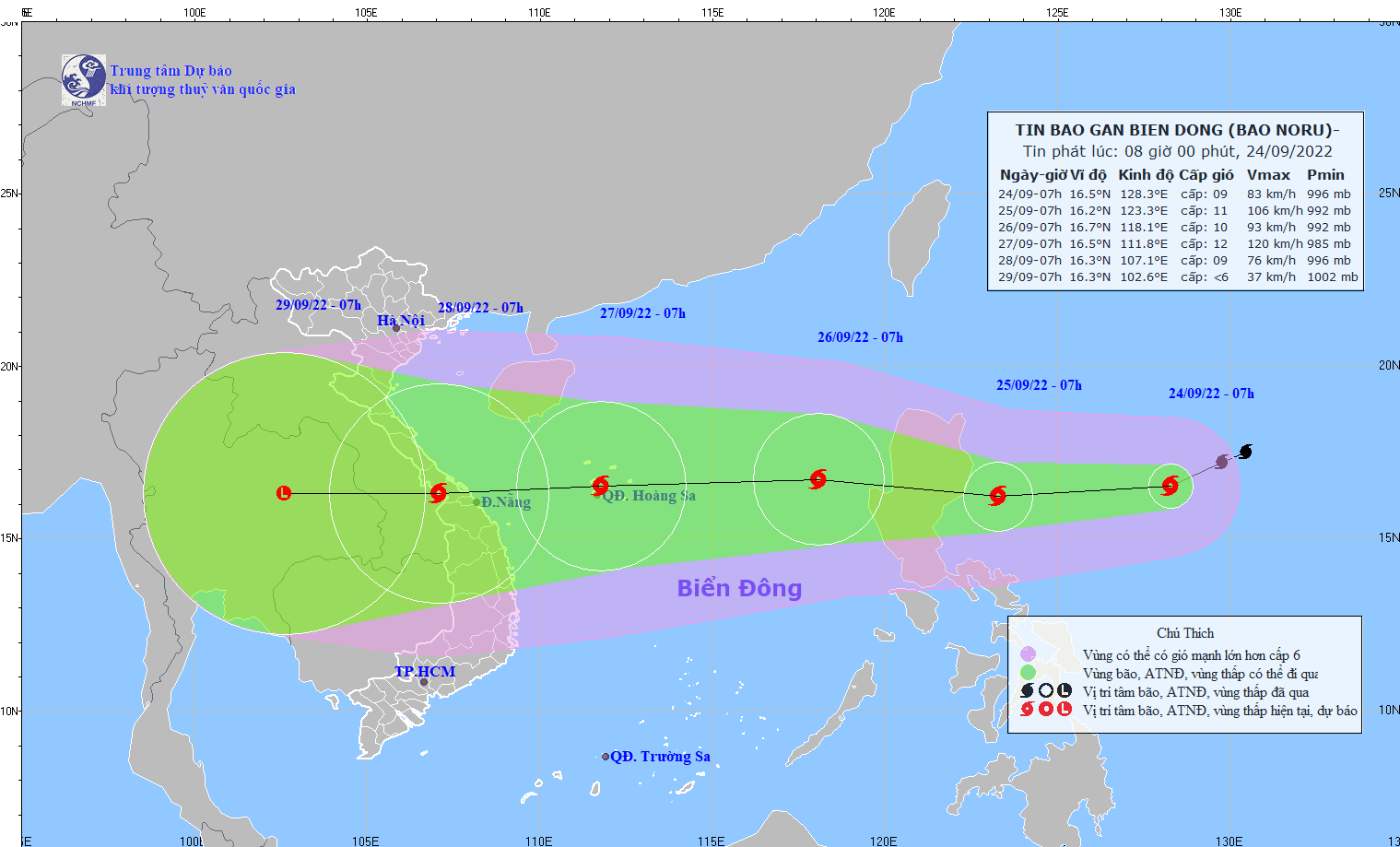
| The expected track of storm Noru. Photo: NCHMF |
In its latest bulletin, Viet Nam’s National Center for Hydro-meteorological Forecasting (NCHMF) said that storm Noru will likely be in favorable conditions for continued strengthening as it moves into the East Sea on Sunday night, September 25, with the maximum sustained winds reaching levels 9 to 10, and the gusts as high as level 13.
Forecast models indicate at 4:00 pm on Sunday, September 24, the storm was spotted at latitude 15°8'N and longitude 126°6'E, about 500km East of Luzon Island, Philippines, packing maximum sustained winds at level 11, and and gustiness of level 14.
Over the next 24 hours, Noru is set to move general westward at 20 kilometres per hour. At 4:00 pm on Sunday, September 25, the storm will be centred near latitude 15°6'N and longitude 121°1'E, right on Luzon Island, Philippines, with the maximum sustained winds at level 11, and the gusts as high as level 14.
The storm will move the East Sea on Sunday night, September 25 as it tracks west-northwest at 20 kilometres per hour. At 4:00 pm on Monday, September 26, the storm’s center will be located about 510km east of the Hoang Sa Archipelago, with the maximum sustained winds reaching levels 11 to 12, and gustiness of level 15. At 4:00pm on Tuesday, September 27, the storm will be centred near latitude 15°8'N and longitude 110°3'E, about 190km east of the coast of the parts from Thua Thien – Hue to Quang Ngai, including Da Nang, packing maximum sustained winds of levels 12 to 13, and and the gusts as high as level 16.
From Sunday afternoon, September 25, due to the influence of storm Noru, the Northern part and the middle of the East Sea will see gradually increasing strong winds at levels 6 to 7, while the area near the storm’s center will experience high winds at levels 8 to 9, and gustiness of level 11 with rough seas and waves as high as 4m to 6m. A warning for level 3 natural disaster risk has been issued for these areas.
Noru is expected to make landfall as a powerful storm in the morning of September 28 in Central Viet Nam as it tracks quickly westward, according to the latest path from NCHMF.
The maximum sustained winds reaching levels 10 to 11, and the gusts as high as level 14 will affect areas near the storm’s center.
National forecasters indicate heavy rainfall of 100 mm to 200mm in South Central Coast under the influence of storm Noru and wet conditions will continue over the next couple of days.
Viet Nam’s National Steering Committee for Natural Disaster Prevention and Control is urging authorities in coastal parts from from Quang Ninh to Binh Thuan, including Da Nang, to take proactive and necessary mitigation measures in response to powerful storm Noru.
The authorities in the warning areas must keep a close watch on severe weather development, and keep owners of vessels operating at sea timely informed about severe weather conditions in order to help them take the initiative to avoid dangerous areas or seek safe shelters during the bad weather. The focus must be on making the resources available in order to organize timely rescue of any person in distress at sea and provide timely support for those who need it during severe weather.
Fishermen in the warning areas are strongly advised not to venture into sea during the period of typhoon Noru while fishing vessels operating in the East Sea are called to return shore.
In addition, the heed must be paid on assisting local residents to prepare for severe weather in an attempt to keep them safe and protect their properties.
The authorities in the warning areas must continue to take resilience measures to help save lives and reduce the damage to individual houses, public infrastructure and crops. In addition, all necessary steps are needed to move people living in low-lying areas, along rivers and streams and areas at high risk of flash floods and landslides to safe places. Special attention must be given to making the resources available in order to drain rainwater from agricultural fields, low-lying areas, urban areas, most densely populated areas, industrial zones and other areas most at-risk of flooding in an effort to reduce costly damage to crops and property.
According to the Da Nang Steering Committee for Disaster Response and Search and Rescue, fast-moving typhoon Noru has the potential to be a severe storm for Da Nang. Therefore, authorities at local level and relevant units are urged to take proactive steps in response to the hurricane.
Reporting by Baotintuc – HOANG HIEP - Translating by H.L