Airport subdivision planning: Leveraging Da Nang development
The Da Nang airport subdivision planning project with a scale 1/2,000 is identified as a specifically functional area. This will become an important traffic hub of the city, associated with the development of the aerotropolis model.
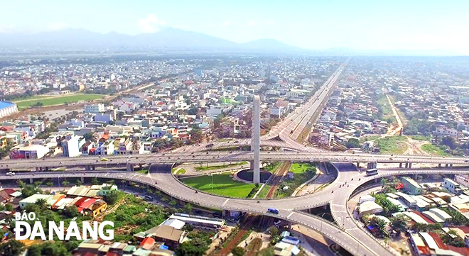 |
| Airport urban zoning planning area viewed from the Hue overpass. Photo: TRAN TRUC |
The airport subdivision is planned to have an area of 1,326.7 hectares, with a forecast population of about 77,000 people by 2030. The site includes part of the area of Hai Chau, Thanh Khe and Cam Le districts, bordering the Nguyen Tri Phuong -Nguyen Huu Tho intersection to the east, Truong Chinh Street to the west, Dien Bien Phu Street to the north and Cach Mang Thang Tam Street to the south.
The aerotropolis will take the shape
According to the planning, the airport subdivision is divided into 2 main areas: the urban construction area and the Da Nang international airport area. This subdivision is organised into 4 development areas with 4 residential units. In particular, the Da Nang international airport area includes area No.1 with development orientation according to the Da Nang international airport adjustment planning project for the 2021-2030 period, with a vision toward 2050.
The urban construction area will be devided into 3 development areas including 4 residential units covering an area of 478.58 hectares and a population of 77,000 people.
Accordingly, the remaining 3 development areas are identified in terms of area, population and development orientation. In detail, area No. 2 is the eastern airport gateway area (unit in DVO-2) with an area of 89.46 hectares and a population of 18,300 people, with the orientation of developing trade and services and tax-free areas to meet the needs of airport passengers and the Da Nang people in general, thereby gradually forming into the aerotropolis model.
Area No. 3 is the southern urban area (unit in DVO-1) with an area of 140.20 hectares and a population of 19,500 people, oriented as an urban embellishment area with the upgrading and adding of infrastructure systems and urban amenities.
Area No. 4 is the northwest urban area (units in DVO-3 and DVO-4) with an area of 248.92 hectares and a population of 39,200 people, oriented to be an area for urban embellishment with the supplement of the urban technical infrastructure system and urban amenities to serve the needs of the general public.
The planning also mentions open spaces designed on the principle of exploiting and protecting the natural landscape, in harmony with the architectural space of the building and in accordance with land use functions. In particular, the highlight of the open space is the gateway to the Da Nang International Airport - the main access point to the city by air.
On the other hand, so as to orient and organise architectural and landscape space, create characteristics and identity for the area, the planning identifies highlight areas will include the International Airport terminal, which is oriented to be a unique and symbolic architectural work; green spaces and water surfaces such as the fitness and a sports park to the south of the airport , the Hoa Tho Park, the Phan Lang canal-side park chain combined with Thanh Khe fitness and sports centre, the Cam Le detention dasin-side park.
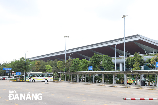 |
| According to the airport zoning plan, the city develops an aviation logistics centre through expanding into a cluster south of Da Nang International Airport. Photo: TRAN TRUC |
Important direction for development
According to the Da Nang Department of Construction, the airport subdivision planning aims to concretize the adjustment of the Da Nang Master Plan for the city’s major developments by 2030, with a vision toward 2045 approved by the Prime Minister in Decision No. 359/QD-TTg dated March 15, 2021. Therefore, the main development directions of the airport subdivision are also determined according to the Da Nang Master Plan.
Accordingly, focus will be on upgrading and supplementing urban technical infrastructure systems and add urban amenities, gradually moving industrial and handicraft establishments and warehouses mixed in residential areas causing environmental pollution to concentrated industrial zones and clusters and converting the functions of these land areas into land serving urban development and national security and defense areas.
In addition, heed will be paid to developing the aviation logistics centre through expanding into a cluster south of the Da Nang International Airport to expand the airport's logistics capacity. On the other hand, the orientation to increase the use of underground space is to ensure economical and effective use of land fund in the city centre, environmental protection as well as security and defence requirements.
According to assessments by the Da Nang Department of Construction, the decision to approve the Airport Zoning Plan has important implications for the city’s development as a whole, thereby helping synchronize project planning and develop urban space in harmony between the current status and propose new construction areas, especially creating a strong driving force for regional economic development in services, becoming a public centre in Da Nang.
Along with that, the airport zoning plan also serves as a basis for functional agencies to carry out planning management and guide construction investment and synchronous development of social and technical infrastructure systems to ensure urban development in accordance with the city's orientation.
Reporting by TRAN TRUC - Translating by A.THU