Urban subdivision planning along the Han River and in the east of Da Nang
Urban subdivision planning along the Han River and the east bank of the river in Da Nang, including a part of Thanh Khe, Hai Chau, Son Tra and Ngu Hanh Son districts, is oriented towards the city’s goal of developing tourism services. The Da Nang government issued Decision No. 81 on March 28, 2022 on approving the urban zoning along the Han River and the east of the city based on the Prime Minister-approved adjustments to the master plan for Da Nang's major developments by 2030, with a vision to 2045, in which functional subdivision of these areas is to be the essential foundation for urban development and tourism services considered as a key driver of the city’s economic growth.
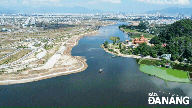 |
| Co Co River linking with Han River becomes a key waterway tourism route between Da Nang and Quang Nam Province. Photo: TRIEU TUNG |
The urban subdivision planning along the Han River and the east of the river which includes a part of Thanh Khe, Hai Chau, Son Tra and Ngu Hanh Son districts, except the Son Tra Peninsula covers an area of 6,644ha with the population of these areas projected to reach 484,000 by 2030. The urban subdivision is defined as the division of these areas for the purpose of developing central area of Da Nang, building a political-administrative center, a financial hub, a centre for high-quality education and training, a hub for sports, culture, health in Central Viet Nam, as well as serving as a major tourism gateway for riverside and coastal routes, and a national and international convention center. Therefore, the focus is on ensuring a sustainable development path while creating the urban planning on both social and technical infrastructure.
Land use planning for school sites requires the minimum area of 0.6 square metres per child with 0.65 square metres per child required for elementary education while 0.55 square metres required for a junior high school student. Land used for cultural and sporting events requires 0.5 square metres a person, and 0.5 square metres a person for training ground. A minimum area of 0.3 ha is required for a sports field, at least 5,000 square metres for a sports center, and 500 square metres for a medical station.
The minimum land area used for each traditional market is 2,500 square metres. The heed will be paid to ensure that the entire population of the planned areas has access to clean water with the target of 170 liters of water per person a day. Special attention will be given to reach 100% wastewater collection coverage in the planned urban areas.
The planning on both social and technical infrastructure is required to ensure effective and efficient utilization of the city’s land fund, create a driver for urban development and economic growth, as well as provide the synchronization and harmony between inside and outside the urban subdivision along the Han River and the east of the city.
The organization of urban space and architectural design is based on features of current urban development and all surface-water features such as rivers, streams, lakes. The focus will be on effectively managing public space while connecting the east bank with west one of the Han River, as well as ensure continuity of central areas of the city and coastal functional areas. The heed will be paid to create a magnet to attract tourists and investors by developing modern and lively riverside and coastal areas in an attempt to promote the development of world-class tourism properties. The master plan for Da Nang's major developments also identifies the development of the Tien Sa Port into a port for cruise tourism, the construction of Auxiliary Services Functional Areas for cruise tourism in a bid to serve as a large coastal gateway in Central Viet Nam.
The urban zoning along the Han River and the east of the city requires renovation and rebuilding of the central areas of the existing urban areas, the development of trade and services sector, land allocation for developing social infrastructure and urban utilities, a planned residential unit development for the purpose of promoting trade and services sector, mixed land-use planning in riverside and coastal areas to drive development of tourism and trade.
The city’s architectural space highlights are tourist attractions that stretch from the Da Nang Bay, the area along the Han River to the area bordering Quang Nam Province, the water tourism route from Da Nang by Song Han Port, then by Co Co river to Quang Nam Province’s Hoi An City, and the sea route connecting Da Nang with Cham Islands.
Spatial planning along the Han River and in the east of the city features main centers with a square associated with the city’s Administrative Center, software parks, facilities for sports and culture around Tien Son Sports Palace, the living museum, the trade center axis of Hung Vuong Route associated with Con and Han markets, Bach Dang walking street associated with the APEC Sculpture Garden, night market, fun water activities along the Han River and coastal areas. In addition, urban plannning focusses on transforming the An Don Industrial Park (IP) into an eco-IP, establishing a new commercial center, forming a financial street along Vo Van Kiet with a financial, commercial, and entertainment complex, and developing international convention centres.
Reporting by TRIEU TUNG – translating by H.L