Tropical depression to hit East Sea this week
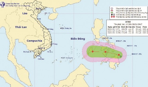
A tropical depression occurring south of the Philippines has been forecast to reach the East Sea later this week and potentially form a storm.
 |
| A map detailing the journey of the tropical depression from January 8 to 10, 2017. P Nat'l Centre for Hydro-meteorological Forecasting |
The low-pressure system was located in the area east of the southern Philippines on Sunday night, packing winds of up to 60km/h and squalls of up to 102km/h, according to the National Centre for Hydro-Meteorological Forecasting.
The depression is expected to travel southwest at about 10 to 15km per hour, the center added.
Director Hoang Duc Cuong warned that the system would enter the East Sea on Tuesday and gather strength to become a storm.
Under the influence of an enhanced cold front and storm circulation, it is forecast to rain in northern Viet Nam, especially in the northwest region.
The weather conditions in the southern part of the East Sea will also worsen in the next few days, Cuong added, before saying that the development of the tropical depression needs to be closely monitored.
A tropical depression or typhoon in the maritime area at this time of the year is not unprecedented, Cuong explained, listing the examples of storm Melor, which formed in late December 2015, or Sonamu, striking the same region in early January 2013.
However, these storms often weaken quickly during their journeys at sea due to the effect of cold fronts coming from the north.
(Source: Tuoitrenews)


