Bitterly cold air to come across parts of Viet Nam from Friday into next week
Viet Nam's National Center for Hydro-meteorological Forecasting has underlined a must-do to ensure cold-resistant measures for the populace and livestock as the mercury is now on a significant downward trend in Northern and Central Viet Nam as an intense cold front slams Viet Nam.
 |
| From Friday, 8 January, Da Nang is bracing for a sharp plunge in its temperatures. (Illustrative image sourced from the Internet) |
The “severe cold weather conditions” are expected to bring more chances of frost and sleet, a mixture of rain and snow, to upland territories in Northern Viet Nam.
From Thursday into next Tuesday (12 January), Northern Viet Nam, especially the provinces of Lao Cai, Tuyen Quang, Ha Giang, Cao Bang, Bac Kan and Lang Son, will be the hardest hit.
The average lows are projected to fall to only 8 – 11 degrees Celsius in many parts of these northern localities, dip to 4 and 7 degrees Celsius in mountainous areas, and below 0 degrees Celsius at mountaintops.
In particular, over the few coming days, it is likely to sleet at locations over 2,000 meters high.
At other summits below 2,000 meters high, the low temperature will result in frost, national meteorologists warned.
Likewise, the weather will also turn frigid in northern and north-central Viet Nam from tonight, 7 January. A vast stretch from Quang Binh to Thua Thien-Hue provinces is predicted to suffer chiller weather with the mercury plummeting considerably.
Of special note, from Friday into next week, Da Nang is projected to experience a sharp plunge in its temperatures. This weekend will see the mercury plummet to hover at from 17 – 18 degrees Celsius in many of its parts and brace for very unpleasant showers across Da Nang.
On 11 January, further spell of cold weather which is forecast to be stronger than the previous ones will sweep across many parts of Viet Nam, and of course, causing Da Nang to suffer even chillier weather.
The lowest temperatures of 14 - 16 degrees Celsius are highly possible at night and in the early morning of 11, 12, and 13 January. This is the lowest point since January 2016 to be recorded in Da Nang.
Meanwhile, Hoang Sa waters are projected to experience strong winds at levels 7 - 8, with a gusts of level 10, sea waves from 5 to 7 m high, and very rough sea.
According to national meteorologists’ projections, by late February, some spells of cold weather are forecast to hit many parts of Viet Nam, with each staying in place for 7 – 10 days.
The chilly weather-hit localities have been required to build up a framework for implementing and coordinating cold weather preparedness and response activities which focus on reducing the negative health impacts of cold weather conditions.
Of special note, to stay ‘safe and sound’ during inevitable severe cold spells bringing very high humidity, drizzle and blustery winds without sunshine, it is a need for the general public to wrap up in an extra layer of clothing in an effort to stay warm.
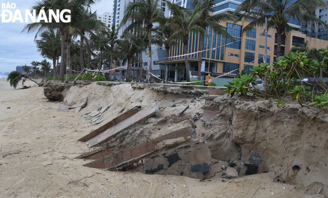
Northern and central coastal localities, including Da Nang, are highly recommended to take proactive measures to potential devastating erosions in light of upcoming strong cold fronts, strong winds, heavy rough seas, high waves and rising sea-levels.
 |
| A part of the T18 beach in My An Ward, Ngu Hanh Son District, Da Nang has recently been severely hit by erosion |
The La Nina phenomenon will continue through the first half of 2021, and then the climate will shift to the neutral conditions in summer 2021, the national forcasters said.
As a result, heat waves in summer months of 2021 will occur in the northern and central regions later than and be less severe than in 2020.
Storms and tropical depressions are forecast to happen in the East Sea earlier than in 2020, and hit Viet Nam mainly at the last months of the year.
By HOANG HIEP/TTXVN - Translated by A.T


