Heavy rains cause Cu De and Yen rivers overflow, flooding in some rural areas in Da Nang
Very heavy rainfall has caused the upstream of Cu De River to burst its banks, leaving roads in Nam Yen Village flooded and Loc My Village isolated, both in Hoa Vang Rural District, overnight Saturday night into the early morning of Sunday. Overflowing Yen River poses flood risk in some roads in Hoa Vang and Cam Le districts from the midday today, October 17.
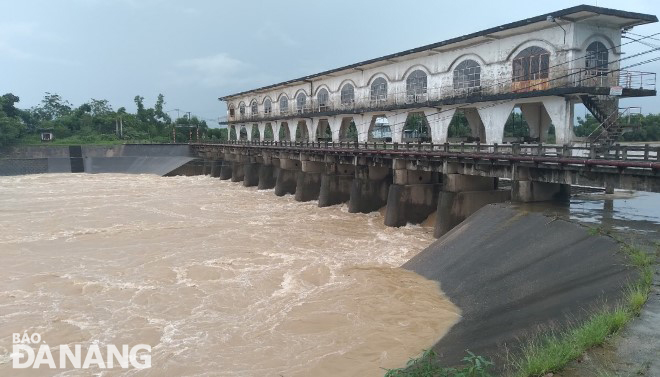 |
| The water level on the Yen River at upstream of the An Trach dam is rising rapidly. Photo: HOANG HIEP |
At 3:50 am on Sunday, the upstream of the Cu De River in Ta Lang Village, Hoa Bac Commune peaked at 12.83m, water levels on the river saw significant increases as a result of heavy rainfall. More discharge from upstream caused the Cu De River at the part of Truong Dinh bridge to rise 2m above the normal level.
At 6:00 am on Sunday, some roads in Nam Yen village in Hoa Bac Commune were flooded and Loc My Village in Hoa Bac Commune was isolated due to flooding.
Meanwhile, discharges from three reservoirs into downstream of the Vu Gia River reach 1,613m3/s. In which, discharges from reservoir of the Song Tranh 2 hydropower plant are only 5.7 m3/s.
At 4:00 am on Sunday, water levels on the Vu Gia River at the part of the Ai Nghia Hydrological Station reached 6.75m, 0.25m above alarm level 1 as a result of heavy rains and water discharged by reservoirs.
Water level on the Yen River at upstream of the An Trach Damp is rising at the speed of 18 to 20cm per hour. From the midday today, October 17, some low-lying roads in Hoa Vang and Cam Le districts could be underwater, and floodwater will continue to rise on Sunday evening.
The Quang Nam Centre for Hydro-meteorological Forecasting says that water levels on the Vu Gia River will continue to rise, and peak at alarm level 2 or above, and floodwaters will slowly recede afterward.
The water level on Vu Gia river at the part of the Ai Nghia Hydrological Station is expected to peak at the midday on October 17 at 8.1m, 0.1m above alarm level 2. Meanwhile, the water level on the Thu Bon River is likely to rise at alarm level 1 or above.
The Mid-Central Region Centre for Hydro-meteorological Forecasting has predicted heavy to very heavy rainfall in the parts from Quang Binh to Quang Ngai, including Da Nang, from the early morning of October 17 into October 17 due to the combined influence of cold air and the intertropical convergence zone. By the coast they will see strong winds at level 3 to 4 and the gusts as high as level at 5 to 6, and farther inland you could find northeast winds at level 3.
The coastal areas from Quang Binh to Quang Ngai, including Da Nang, will see gradually increasing wind at level 6-7, and the gusts reaching level 8, and experience rough seas.
Reporting by HOANG HIEP – translating by H.L