Storm No. 8 continues fast track west, heavy rain forecast for Central Viet Nam from Oct.16
The newly-developed storm No. 8 is expected to move into the waters to the south of the Gulf of Tonkin in the early morning of Thursday, October 14, with the maximum sustained winds reaching level 9, and the gusts as high as level 11.
Heavy to very heavy rainfall are forecast for Central Viet Nam from October 16 due to the effect of intensification of the cold front and the intertropical convergence zone
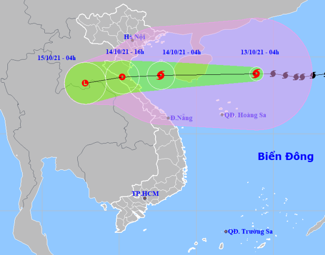 |
| The expected track of the newly-developed storm No. 8 (Source: Viet Nam’s National Centre for Hydro-Meteorological Forecasting) |
In its latest bulletin, Viet Nam’s National Centre for Hydro-Meteorological Forecasting said at 4:00 am today, October 13, the newly-developed storm's center was positioned at latitude 18°9'N and longitude 113°9'E, about 270km northeast of the Hoang Sa (Paracel) Islands, packing maximum sustained winds at level 11 and gustiness of up to level 14.
The radius of strong winds at level 6 and the gusts as high as level 8 is about 350km from the storm’s center.
The storm will continue to move very quickly to the west at 25-30 km per hour and it is expected to move into the waters to the south of the Gulf of Tonkin. It is likely to reduce its intensity gradually thereafter.
At 4: 00am on Thursday, October 14, the storm's center will be positioned at latitude 18°8'N and longitude 107°7'E , with the maximum sustained winds reaching level 9, and the gusts as high as level 11.
The storm will continue moving west at about 20 km per hour. It is forecast to weaken to a tropical depression after making landfall in the parts from Thanh Hoa to Quang Binh.
Wednesday night into Thursday, the coastal areas from Quang Ninh to Quang Binh, will see gradually increasing wind at level 6-7, and the gusts reaching level 9. Some places in the northern region will experience strong winds at level 8, and gustiness of up to level 10.
The Gulf of Tonkin (including Bach Long Vi Island) and the offshore areas stretching from Quang Tri to Quang Ngai (including Con Co Island) will see strong winds at level 6, then increase to level 7-8. The area near the center of the storm will experience strong winds at level 9 and the gusts as high as level 11, rough seas with waves as high as 3-5 m.
The sea level in coastal areas in the parts from Thai Binh to Ha Tinh is projected to rise by 0.4-0.6 m accompanied by high tides, posing flood threat to low-lying areas on the morning of October 14.
Wednesday afternoon into Friday, heavy rain is forecast for the northern region and Quang Tri, with a common rainfall of 100-150 mm, and forecasters warning more than 200mm could fall in some places. The parts from Thanh Hoa to Quang Binh will brace for very heavy rain with a common rainfall of 200-300 mm, and even more than 350 mm in some places.
Forecasters have also issued warnings of flash floods and landslides for mountainous areas, and localized flooding alerts are in place in low-lying areas and riverside areas.
Reporting by HOANG HIEP – translating by H.L