Da Nang issues advisory to prevent injuries after storm Noru as heavy rain and strong winds continue in the city
Typhoon Noru made lanfall over the parts from Da Nang to Quang Nam Province early Wednesday morning. The storm was forecast to bring powerful winds and heavy rain that prompted local authorities in affected areas to evacuate hundreds of thousands of people.
The typhoon weakened a little prior to making landfall, but was still equivalent to a high-end Category 2 hurricane with winds near 175 km per hour.
It will continue to bring strong winds and surges along the coastal areas of Da Nang and is expected to weaken as it pushes inland over Central Viet Nam, southern Laos, and northern Thailand could face a risk of floods over the next 48 hours.
Therefore, warning for heavy rain and high winds remains in place over Da Nang. The national weather service indicate heavy rainfall of 50 mm to 100mm in Da Nang, and even in excess of 100mm at isolated places for Wednesday while the city could see high winds at levels 8 to 9.
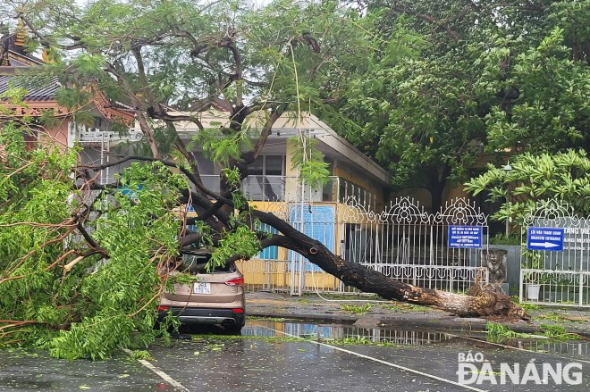 |
| A tree falling on a car during the storm near the Da Nang Museum of Cham Sculpture on the September 2 Street. Photo: HOANG HIEP |
The Da Nang Steering Committee for Natural Disaster Prevention, Search and Rescue and Civil Defence on Wednesday urged authorities at local level and relevant agencies to take all necessary measures to ensure the safety of local residents after storm Noru.
Focus must be keeping a close watch on severe weather development after storm Noru, and keep local residents timely informed about severe weather conditions in order to help them protect their property from bad weather.
The Da Nang government is asking residents to remain vigilant with more heavy rain on the way and potentially hazardous conditions, including strong winds, big wages, flooding and landslides, thereby urging them take all necessary precautionary safety measures to prevent injuries.
Local residents are strongly advised to not repair their damaged house caused by the storm unless it's 'absolutely necessary or conduct other unnecessary activities to avoid serious accidents. In addition, the public should not travel along or conduct fishing activities at sea, rivers, streams, lakes, dams, low-lying areas, and flood and landslide vunerable areas.
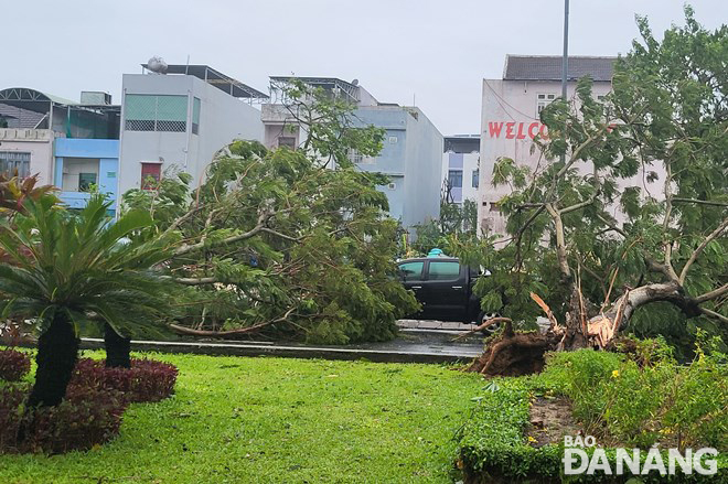 |
| An uprooted tree during the storm on the April 30 Street. Photo: HOANG HIEP |
In its latest bulletin, Viet Nam’s National Center for Hydro-meteorological Forecasting (NCHMF) said at 7:00 am on Wednesday, the storm's centre was already spotted near latitude 15°8'N and longitude 107°5'E, sat over the parts from Thua Thien- Hue to Quang Ngai. The maximum sustained winds reaching at level 8 (62-74km per hour), and the gusts as high as level at 10 affected areas near the storm’s center. The radius of strong winds at level 6 and gustiness of level 8 or higher was about 120km from the storm’s center.
Over the next 12 hours, forecast models indicate that the storm will move generally westward at 20-25km per hour and then gradually weaken into a tropical depression as it pushes inland over Central Vietnam, and southern Laos. The depression will be then downgraded to a remnant area of low pressure over Thailand. The maximum sustainable winds at the center of the remnant low-pressure system will decrease below level 6 (below 39km per hour).
National forecasters issue advisory for strong winds and big waves at sea as the offshore areas stretching from Quang Binh to Phu Yen (including Con Co, Cham, and Ly Son islands) could see strong winds at levels 6 to 7, and gustiness of levels at 8 to 9 with rough seas and waves as high as 2m to 4m.
A high wind warning has been issued for the mainland of Central Viet Nam as Thua Thien Hue, Da Nang, Quang Nam, Quang Ngai, Binh Dinh, Gia Lai will experience high winds at levels 6 to 7 while the area near the storm’s center will see strong winds at level 9, and gusts at level 10. Quang Binh, Quang Tri, Phu Yen and Kon Tum will see strong winds of level 6, and gusts at level 8.
On Wednesday, very heavy rainfall is predicted in Quang Tri, Thua Thien- Hue, Da Nang, Quang Nam, Quang Ngai, Kon Tum as these areas could receive between 100mm and 150mm of rain, with more than 200mm possible in some places. In addition, national forecasters indicate heavy to very rainfall of 40 mm to 80mm in Quang Binh, Binh Dinh and Gia Lai, and even in excess of 120mm at isolated places. The best chances for moderate to heavy rain will be in North Central Coast Wednesday into Thursday.
Reporting by HOANG HIEP – Translating by H.L