Typhoon Noru path to hit Mid-central region as storm intensifies, Da Nang expected to see wind gusts on Tuesday evening
Typhoon Noru is on track to hit the Mid-central region as early as Wednesday morning, according to Viet Nam’s National Centre for Hydro-Meteorological Forecasting (NCHMF).
Noru is forecast to undergo rapid intensification as it moves through the East Sea and much of the Mid-central region is placed under a hurricane warning.
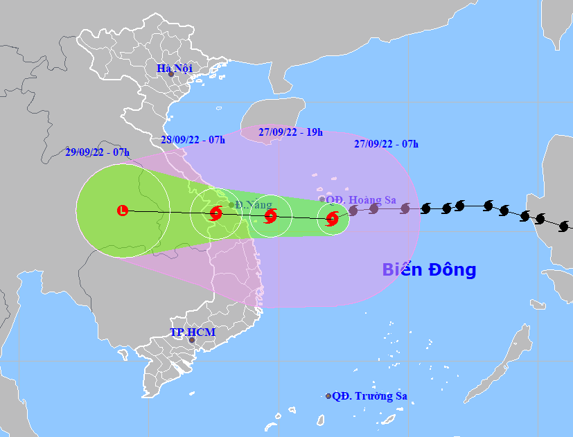 |
| The projected Noru path and map (Source: NCHMF) |
Forecast models indicate that at 7:00am on Tuesday, September 27, the storm’s centre was already spotted at near latitude 15°5'N and longitude 112°1'E, lied to south of Hoang Sa Archipelago, about 360km east coast of the parts from Da Nang to Quang Ngai, packaging maximum sustained winds reaching levels at 14 to 15, and the gusts as high as above level 17. The radius of strong winds at level 10 and gustiness of level 12 was about 150km from the storm’s center.
Noru is forecast to intensify rapidly into a major hurricane as it moves generally westward at 25km per hour. At 7:00 pm on Tuesday, September 27, the storm will be centred near latitude 15°6'N and longitude 109°7'E, about 170km southeast of Da Nang, about 120km east of the parts from Quang Nam to Quang Ngai, with maximum sustained winds reaching level 15, and the gusts as high as above level 17.
Noru will continue to move generally westward at 20-25km per hour and then gradually weaken into a tropical depression after making landfall over the Mid-central region early Wednesday morning. The depression will be then downgraded to a remnant area of low pressure over Thailand.
The storm is forecast to head towards the Mid-central region as it continues its track westward at 20-25km per hour. At 7:00 am on Wednesday, September 28, the storm's centre will be positioned near latitude 15°7'N and longitude 107°6'E , right on the mainland of the parts from Quang Tri to Quang Ngai, including Da Nang, packaging maximum sustained winds reaching levels at 11 to 12, and the gusts as high as level 15.
From Tuesday morning, September 27, the offshore areas stretching from Quang Binh to Ninh Thuan (including Con Co, Cham, and Ly Son islands) could see strong winds at levels 8 to 9, then increase to levels 10 to 11 while the area near the storm’s center will experience high winds at levels 13 to 14, and gustiness of level 16 with rough seas and waves as high as 8m to 10m.
From Tuesday afternoon, September 27, the coastal areas from Thua Thien Hue to Binh Dinh will experience high winds at levels 9 to 10, then increase to levels 11 to 12 while the area near the storm’s center will see strong winds at levels 13 to 14, and gustiness of level 16 with rough seas and waves as high as 6m to 8m.
A storm surge warning has been issued for the parts from Quang Binh to Quang Nam with 1.2m–1.7m surge alert, that could cause flooding in low-lying areas near ocean and estuaries. An advisory for strong winds, big waves, tornadoes and storm surge has been also issued for all vessels and marine farms operating in these areas.
From Tuesday evening and night, September 27, the coastal areas in Thua Thien- Hue, Da Nang, Quang Nam, Quang Ngai and Binh Dinh will see high winds at levels 9 to 10 while farther inland could see maximum sustained winds at levels 8 to 9, and and gustiness of levels at 12 to 13. The maximum sustained winds reaching levels 12 to 13, and the gusts as high as levels at 14 to 15 will affect areas near the storm’s center. Meanwhile, Quang Binh, Quang Tri and Phu Yen could experience strong winds at level 6, then increase to levels 7 to 8, and gustiness of levels 9 to 10.
Tuesday into Wednesday, very heavy rainfall is predicted in Quang Tri, Thua Thien- Hue, Da Nang, Quang Nam, Quang Ngai, Kon Tum as these areas could receive between 300mm and 400mm of rain, with more than 450mm possible in some places. In addition, national forecasters indicate heavy to very rainfall of 100 mm to 200mm in Quang Binh, Binh Dinh and Gia Lai, and even in excess of 300mm at isolated places.
Reporting by HOANG HIEP – Translating by H.L