Noru expected to move closer coastline of the parts from Thua Thien – Hue to Quang Ngai at 1am tomorrow
Due to the influence of typhoon Noru, Quang Ngai Province’s Ly Son Island has seen strong winds at level 8, and gusts at level 11 while Binh Thuan Province’s Phu Quy Island has experienced high winds at level 6, and gusts at level 7. In particular, strong winds and heavy rain are battering Da Nang.
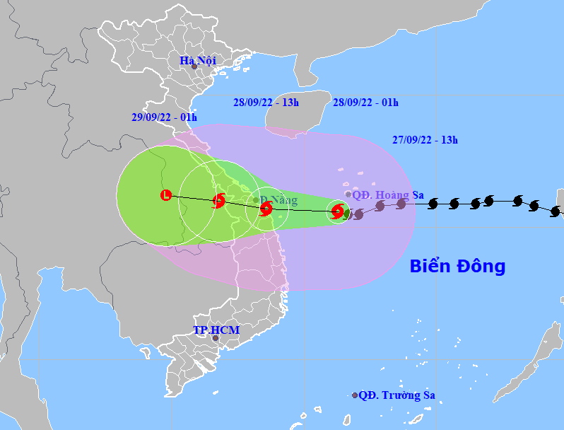
Forecast models indicate that at 1:00am on Wednesday, the storm will be centred near latitude 15°7'N and longitude 108°6'E, sit over the waters off the coast of the parts from Thua Thien- Hue to Quang Ngai, including Da Nang, packaging maximum sustained winds reaching levels at 14 to 15, and the gusts as high as level 17.
 |
| Typhoon Noru latest projected path and map (Source: NCHMF) |
In its latest bulletin, Viet Nam’s National Center for Hydro-meteorological Forecasting (NCHMF) said that at 1:00pm on Tuesday, the storm's centre was already spotted near latitude 15°6'N and longitude 111°3'E, lie to southwest of Hoang Sa Archipelago, about 270km east of the mainland of the parts from Da Nang to Quang Ngai, with the maximum sustained winds reaching levels 14 to 15, and the gusts as high as above level 17. The radius of strong winds at level 10 and gustiness of level 12 was about 150km from the storm’s center.
Over the next 12 hours, the storm is set to move generally westward at 20-25km per hour. At 1:00 am on Wednesday, the storm's centre will be positioned near latitude 15°7'N and longitude 108°6'E, sit over on the waters off the coast of the parts from Thua Thien- Hue to Quang Ngai, including Da Nang, packaging maximum sustained winds reaching levels at 14 to 15, and the gusts as high as level 17.
Noru will continue its track towards west at 20-25km per hour, and then gradually weaken into a tropical depression after making landfall over the Mid-central region early Wednesday morning.
At 1:00pm on Wednesday, the depression will be centred near latitude 16°N and longitude 106°8'E, right on southern Laos, with the maximum sustained winds reaching levels at 8, and gusts at level 10. The depression will be then downgraded to a remnant area of low pressure over Thailand.
Due to the influence of typhoon Noru, the offshore areas stretching from Quang Binh to Ninh Thuan (including Con Co, Cham, and Ly Son islands) could see strong winds at levels 8 to 9, then increase to levels 10 to 11 while the area near the storm’s center will experience high winds at levels 14 to 15, and gustiness of level 17 with rough seas and waves as high as 9m to 11m.
The coastal areas from Thua Thien Hue to Binh Dinh will experience high winds at levels 9 to 10, then increase to levels 12 to 13 while the area near the storm’s center will see strong winds at levels 14 to 15, and gustiness of level 17 with rough seas and waves as high as 6m to 8m.
The national weather service issues storm surge watches and warnings for the parts from Quang Binh to Quang Ngai, including Da Nang, with 1.2m–1.7m surge alert. In particular, Quang Binh could see a surge of 1.6m, Quang Tri with a surge of 2m, Thua Thien- Hue with a surge of 1.8m, Da Nang with a surge of 2.5m, Quang Nam with a surge of 2.5m, and Quang Ngai with a surge of 1.5m. National forecasters also issue flooding warnings for low-lying areas near ocean and estuaries due to storm surge and high waves.
From Tuesday evening, the coastal areas in Thua Thien- Hue, Da Nang, Quang Nam, Quang Ngai and Binh Dinh will see high winds at levels 9 to 10. Farther inland could see maximum sustained winds at levels 9 to 10, and and gustiness of levels at 12 to 13. The maximum sustained winds reaching levels 12 to 14, and the gusts as high as level 15 will affect areas near the storm’s center. Meanwhile, Quang Binh, Quang Tri and Phu Yen could experience strong winds at level 6, then increase to levels 7 to 8, and gustiness of levels 9 to 10.
Reporting by HOANG HIEP – Translating by H.L