Typhoon Noru expected to bring strong winds to waters off coast of the parts from Thua Thien- Hue to Quang Ngai on early Tuesday morning
Meteorologists at Viet Nam’s National Centre for Hydro-Meteorological Forecasting are keeping an eye on typhoon Noru that is set to move into the East Sea on Sunday night.
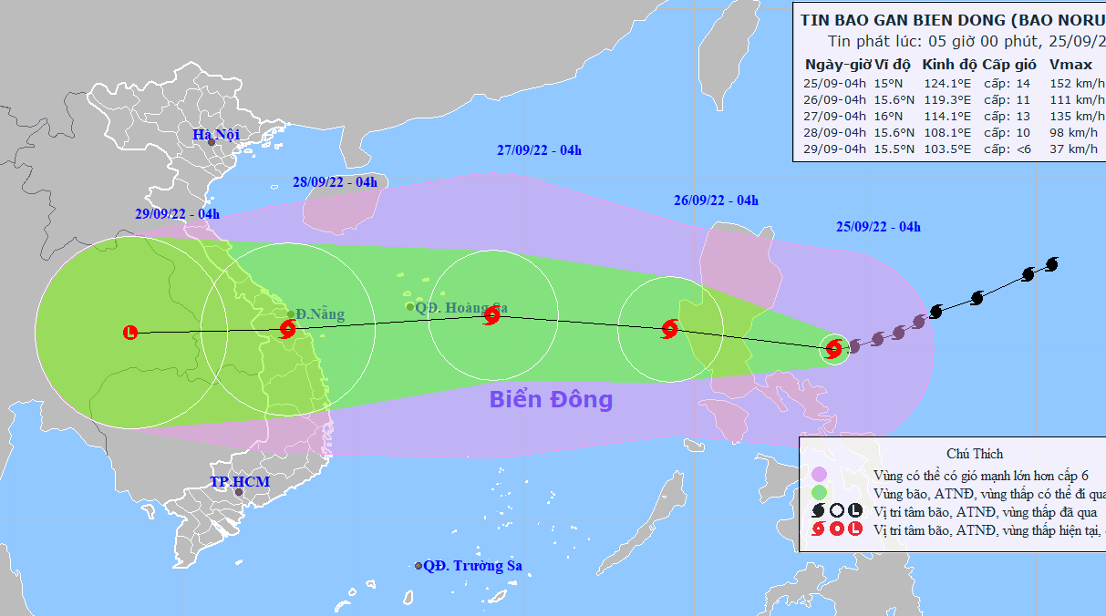 |
| Typhoon Noru’s latest path (Source: Viet Nam’s National Centre for Hydro-Meteorological Forecasting) |
Forecast models indicate at 4:00am on Sunday, September 25, the storm’s center was spotted at latitude 15°N and longitude 124°1'E, about 300km east of Luzon Island, Philippines, packing maximum sustained winds at level 14, and and gustiness of level 17.
Over the next 24 hours, Noru is set to enter the East Sea as it moves generally west- northwestward at 20-25 kilometres per hour. At 4:00am on Monday, September 26, the storm will be centred at near latitude 15°6'N and longitude 119°3'E, about 850km east of the Hoang Sa Archipelago, with the maximum sustained winds at level 11, and the gusts as high as level 14.
Over the next 24 hours, an advisory for strong winds, high waves and tornadoes has been issued for all vessels operating in the potentially dangerous area which is set to be located at latitude 13°N -19°N and longitude 116°E.
Environmental conditions are forecast to be conducive for development while the storm moves generally westward at 20-25 kilometres per hour, and it is expected to grow even stronger.
At 4:00am on Tuesday, September 27, the storm’s center will be positioned at near 16°N and longitude 114°1'E, about 260km east of the Hoang Sa Archipelago, packing maximum sustained winds at level 13, and gustiness of level 16. The danger area in the East Sea Sea around the tropical storm which is set to be located at near latitude 12°5' N - 20°N and longitude 110°E.
Noru will then change its direction toward west-southwest at 25-30 kilometres per hour. A high wind watch has been issued for waters off coast of the parts from Thua Thien- Hue to Quang Ngai, including Da Nang for early Tuesday morning, September 27. The National Weather Service is predicting sustained winds at around level 13 with gusty winds at level 16.
At 4:00am on Wednesday, September 28, Noru will be centred at near latitude 15°6'N and longitude 108°1'E, and make landfall over the parts from Thua Thien- Hue to Quang Ngai, including Da Nang, with the maximum sustained winds at level 10, and the gusts as high as level 13.
From Sunday afternoon, September 25, due to the influence of typhoon Noru, the Northern part and the middle of the East Sea will see gradually increasing strong winds at levels 6 to 7, then increase to levels 8 to 9 while the area near the storm’s center will experience high winds at levels 10 to 11, and gustiness of level 14 with rough seas and waves as high as 5m to 7m.
Reporting by HOANG HIEP – Translating by H.L