Tropical depression strengthens into storm No. 7, flood risk in some streets in Hoa Vang District
The newly-developed tropical depression strengthened into the storm No. 7 over the East Sea in the early morning of October 8, according to the latest advisory from Viet Nam’s National Centre for Hydro-Meteorological Forecasting) . Rising water levels on Vu Gia River pose flood risk in some low-lying roads in Hoa Vang District, Da Nang.
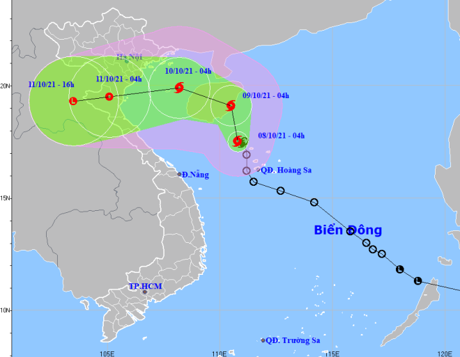 |
| The expected tracked of the newly-formed storm No. 7 (Source: Viet Nam’s National Centre for Hydro-Meteorological Forecasting) |
In its latest bulletin, Viet Nam’s National Centre for Hydro-Meteorological Forecasting said, water levels on the Vu Gia River are high and are increasing due to the storm No.7. The national forecasters said that flood water level on the Vu Gia River at the Ai Nghia Hydrological Station will reach 8.6m from 9:30am to 3:30pm today, October 8, 0.4m below alarm level 3, then recede.
From Thursday evening into early morning of Friday, mountainous areas in the northwestern part of Quang Nam Province experienced heavy rainfall, leading to high amounts of water flowing in reservoirs of such hydropower plants as A Vuong, Song Bung 4, Dak Mi 4 in the Vu Gia-Thu Bon river basin. The flood control function of these reservoirs actively worked due to the low water level.
However, due to large amount of water flowing into reservoirs at the end of the Bung and Con rivers, the flood control function of reservoirs donot work, water levels on the Vu Gia River at Thanh My, Hoi Khach, Ai Nghia Hydrological stations rose faster than expected last night.
At 6:30 am on October 8, water levels on the Yen River upstream at An Trach Dam reached 4.88m with velocity up to 12cm per hour. Current rising floodwater level posed flood risk in some low-lying roads along the Yen River in Hoa Vang District on Friday morning.
National forecasters also said that if floodwater is released from the reservoirs into Vu Gia river downstream at a flow of 600-1,000 m3/s, it will raise floods on the Vu Gia River, water levels on the Vu Gia River at Ai Nghia hydrological station will reach 8.2m, 0.2m above alarm level 2 at 7:00am on October 8 and will reach 8.5m, 0.5m below alarm level 3at 1:00 pm. The flood water is expected to recede to 7.45m, 0.55m below alarm level 2 at 7:00 pm today, October 8.
Mountainous areas could face flash flood warnings and potential landslides, and flooding alerts have been issued for low-lying and riverside areas and urban areas in the parts from Quang Binh to Quang Ngai and Kon Tum.
According to the National Center for Hydro-Meteorological Forecasting, at 4 a.m. on October 8, the storm's center was positioned at latitude 17°5'N and longitude 110°8'E, right on the waters off the northwestern coast of the Hoang Sa (Paracel) Islands, packing maximum sustained winds at level 8 and gustiness of up to level 10.
The radius of strong winds at level 6 and the gusts as high as level 8 is about 120km from the storm’s center.
The storm will continue to move toward the north at 10km per hour over the next 24 hours, and it is expected to grow even stronger.
At 4:00am on October 9, it will lie to the southeast of China's Hainan Island with the maximum sustained winds reaching level 8-9, and the gusts as high as level 11.
The storm No. 7 will then change its direction and move toward the west-northwest at about 10km per hour, and enter the Gulf of Tonkin.
At 4:00am on October 10, the storm will be located about 50km east of Bach Long Vi Island with maximum sustained winds of level 8-9, and gustiness of up to level 11.
On October 8, the parts from Quang Binh to Quang Ngai, including Da Nang, and Kon Tum will brace for moderate to heavy rain with a common rainfall of 50-80mm, and even more than 100mm in some places. These areas will experience a rapid decrease of rainfall intensity during the evening and night hours of October 8.
Heavy rainfall is expected across the North Viet Nam and the Northern Central Coastal Region from October 9-12 due to the influence of storm No. 7.
Forecasters have also issued warnings of flash floods and landslides for mountainous areas, and localized flooding alerts are in place in low-lying areas and riverside areas.
Reporting by HOANG HIEP – Translating by H.L